You are here: Home > Network List > KN - Kyrgyz Seismic Telemetry Network Stations List
> Station UCH KN.UCH > Earthquake Result Viewer
UCH KN.UCH - Earthquake Result Viewer
| Earthquake location: |
Mindanao, Philippines |
| Earthquake latitude/longitude: |
6.9/126.6 |
| Earthquake time(UTC): |
2001/01/01 (001) 06:57:04 GMT |
| Earthquake Depth: |
33 km |
| Earthquake Magnitude: |
6.4 MB, 7.2 MS, 7.5 MW, 7.3 ME |
| Earthquake Catalog/Contributor: |
WHDF/NEIC |
|
| Network: |
KN Kyrgyz Seismic Telemetry Network |
| Station: |
UCH KN.UCH |
| Lat/Lon: |
42.23 N/74.51 E |
| Elevation: |
3850 m |
|
| Distance: |
57.8 deg |
| Az: |
316.175 deg |
| Baz: |
112.232 deg |
| Ray Param: |
0.06321782 |
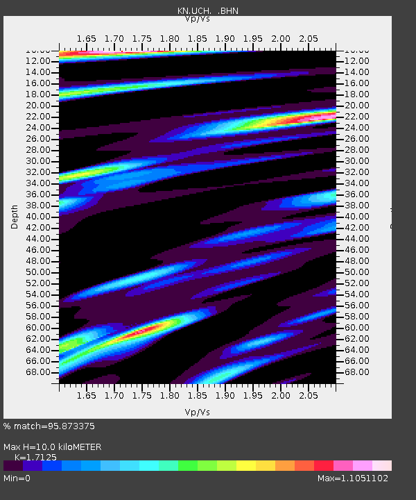
| Estimated Moho Depth: |
10.0 km |
| Estimated Crust Vp/Vs: |
1.71 |
| Assumed Crust Vp: |
6.306 km/s |
| Estimated Crust Vs: |
3.682 km/s |
| Estimated Crust Poisson's Ratio: |
0.24 |
|
| Radial Match: |
95.873375 % |
| Radial Bump: |
400 |
| Transverse Match: |
89.922874 % |
| Transverse Bump: |
400 |
| SOD ConfigId: |
3744 |
| Insert Time: |
2010-03-08 21:22:26.955 +0000 |
| GWidth: |
2.5 |
| Max Bumps: |
400 |
| Tol: |
0.001 |
|
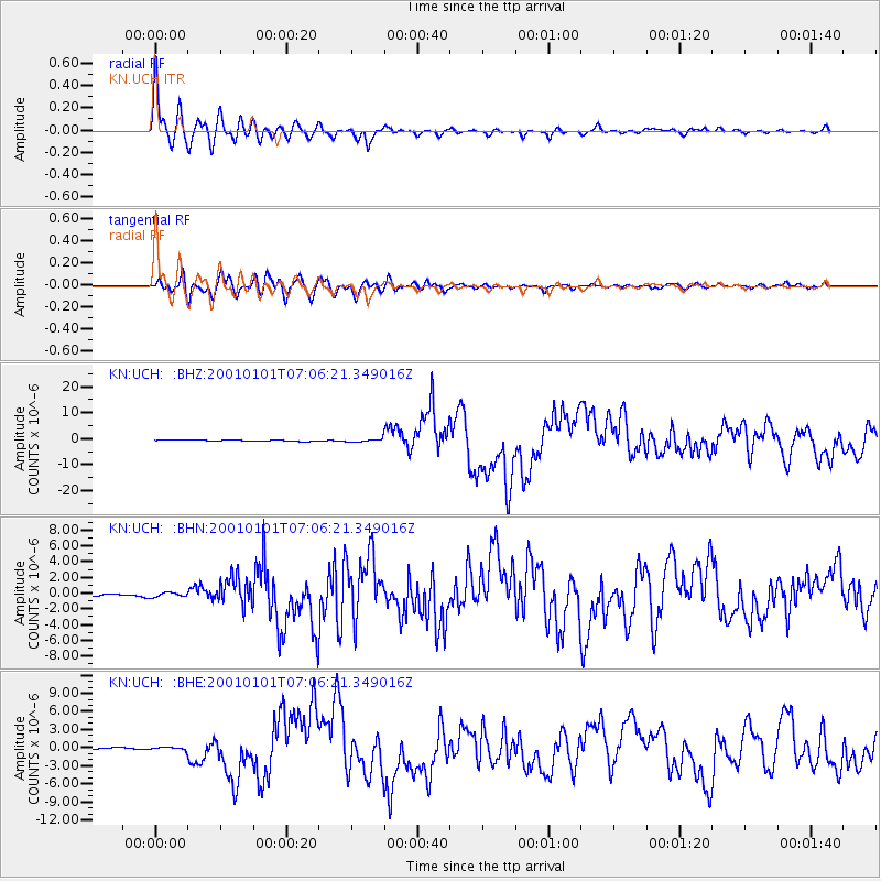
Signal To Noise
| Channel | StoN | STA | LTA |
| KN:UCH: :BHN:20010101T07:06:21.349016Z | 1.2198551 | 2.8282167E-7 | 2.3184859E-7 |
| KN:UCH: :BHE:20010101T07:06:21.349016Z | 1.3624992 | 2.2580451E-7 | 1.6572817E-7 |
| KN:UCH: :BHZ:20010101T07:06:21.349016Z | 2.8845358 | 6.378776E-7 | 2.2113699E-7 |
| Arrivals |
| Ps | 1.2 SECOND |
| PpPs | 4.1 SECOND |
| PsPs/PpSs | 5.3 SECOND |


