You are here: Home > Network List > TA - USArray Transportable Network (new EarthScope stations) Stations List
> Station C36M Paulatuk, NT, CAN > Earthquake Result Viewer
C36M Paulatuk, NT, CAN - Earthquake Result Viewer
| Earthquake location: |
Mariana Islands |
| Earthquake latitude/longitude: |
18.9/145.1 |
| Earthquake time(UTC): |
2020/06/13 (165) 21:08:30 GMT |
| Earthquake Depth: |
622 km |
| Earthquake Magnitude: |
6.2 Mww |
| Earthquake Catalog/Contributor: |
NEIC PDE/us |
|
| Network: |
TA USArray Transportable Network (new EarthScope stations) |
| Station: |
C36M Paulatuk, NT, CAN |
| Lat/Lon: |
69.35 N/124.07 W |
| Elevation: |
10 m |
|
| Distance: |
72.7 deg |
| Az: |
21.806 deg |
| Baz: |
277.645 deg |
| Ray Param: |
0.051352374 |
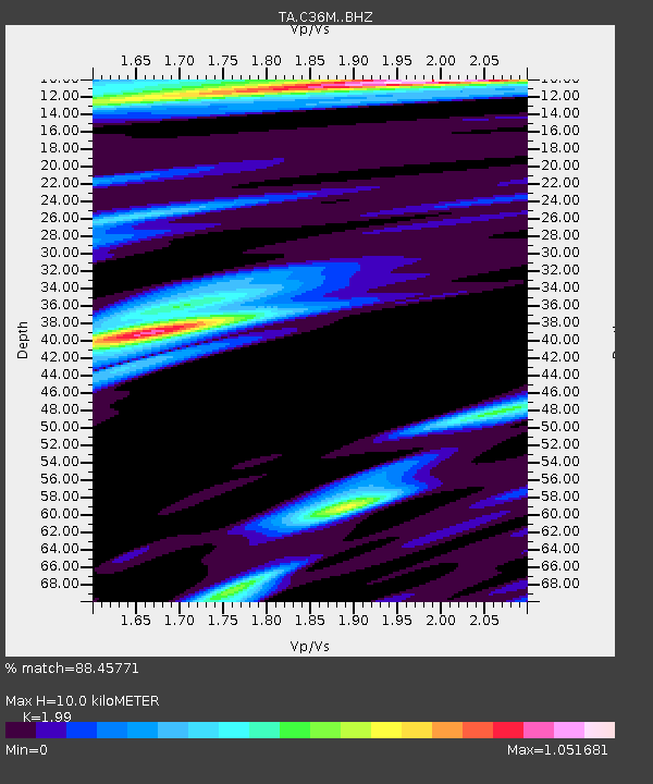
| Estimated Moho Depth: |
10.0 km |
| Estimated Crust Vp/Vs: |
1.99 |
| Assumed Crust Vp: |
6.459 km/s |
| Estimated Crust Vs: |
3.246 km/s |
| Estimated Crust Poisson's Ratio: |
0.33 |
|
| Radial Match: |
88.45771 % |
| Radial Bump: |
346 |
| Transverse Match: |
77.390465 % |
| Transverse Bump: |
330 |
| SOD ConfigId: |
21709731 |
| Insert Time: |
2020-06-27 21:27:39.068 +0000 |
| GWidth: |
2.5 |
| Max Bumps: |
400 |
| Tol: |
0.001 |
|

Signal To Noise
| Channel | StoN | STA | LTA |
| TA:C36M: :BHZ:20200613T21:18:26.174997Z | 17.861235 | 1.9280349E-6 | 1.0794522E-7 |
| TA:C36M: :BHN:20200613T21:18:26.174997Z | 1.2641143 | 1.6522051E-7 | 1.3070061E-7 |
| TA:C36M: :BHE:20200613T21:18:26.174997Z | 5.2620306 | 4.237833E-7 | 8.0536076E-8 |
| Arrivals |
| Ps | 1.6 SECOND |
| PpPs | 4.5 SECOND |
| PsPs/PpSs | 6.1 SECOND |


