You are here: Home > Network List > TA - USArray Transportable Network (new EarthScope stations) Stations List
> Station D17K Noatak River, AK, USA > Earthquake Result Viewer
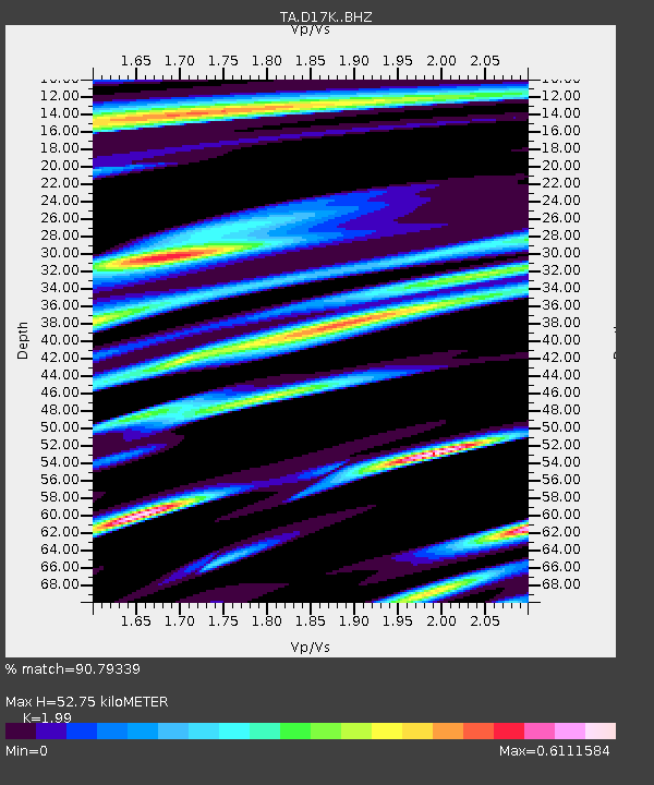
D17K Noatak River, AK, USA - Earthquake Result Viewer
| Earthquake location: |
Mariana Islands |
| Earthquake latitude/longitude: |
18.9/145.1 |
| Earthquake time(UTC): |
2020/06/13 (165) 21:08:30 GMT |
| Earthquake Depth: |
622 km |
| Earthquake Magnitude: |
6.2 Mww |
| Earthquake Catalog/Contributor: |
NEIC PDE/us |
|
| Network: |
TA USArray Transportable Network (new EarthScope stations) |
| Station: |
D17K Noatak River, AK, USA |
| Lat/Lon: |
67.70 N/163.08 W |
| Elevation: |
172 m |
|
| Distance: |
58.6 deg |
| Az: |
20.581 deg |
| Baz: |
240.674 deg |
| Ray Param: |
0.06016036 |
| Estimated Moho Depth: |
52.75 km |
| Estimated Crust Vp/Vs: |
1.99 |
| Assumed Crust Vp: |
6.276 km/s |
| Estimated Crust Vs: |
3.154 km/s |
| Estimated Crust Poisson's Ratio: |
0.33 |
|
| Radial Match: |
90.79339 % |
| Radial Bump: |
400 |
| Transverse Match: |
72.40122 % |
| Transverse Bump: |
400 |
| SOD ConfigId: |
21709731 |
| Insert Time: |
2020-06-27 21:27:41.845 +0000 |
| GWidth: |
2.5 |
| Max Bumps: |
400 |
| Tol: |
0.001 |
|

Signal To Noise
| Channel | StoN | STA | LTA |
| TA:D17K: :BHZ:20200613T21:16:58.574991Z | 13.846845 | 1.0309784E-6 | 7.445584E-8 |
| TA:D17K: :BHN:20200613T21:16:58.574991Z | 6.0490913 | 3.5974932E-7 | 5.9471628E-8 |
| TA:D17K: :BHE:20200613T21:16:58.574991Z | 6.544993 | 3.232867E-7 | 4.939451E-8 |
| Arrivals |
| Ps | 8.6 SECOND |
| PpPs | 24 SECOND |
| PsPs/PpSs | 33 SECOND |


