You are here: Home > Network List > TA - USArray Transportable Network (new EarthScope stations) Stations List
> Station D23K Nanushuk River, AK USA > Earthquake Result Viewer
D23K Nanushuk River, AK USA - Earthquake Result Viewer

| Earthquake location: |
Mariana Islands |
| Earthquake latitude/longitude: |
18.9/145.1 |
| Earthquake time(UTC): |
2020/06/13 (165) 21:08:30 GMT |
| Earthquake Depth: |
622 km |
| Earthquake Magnitude: |
6.2 Mww |
| Earthquake Catalog/Contributor: |
NEIC PDE/us |
|
| Network: |
TA USArray Transportable Network (new EarthScope stations) |
| Station: |
D23K Nanushuk River, AK USA |
| Lat/Lon: |
68.97 N/150.68 W |
| Elevation: |
406 m |
|
| Distance: |
63.3 deg |
| Az: |
21.339 deg |
| Baz: |
252.565 deg |
| Ray Param: |
0.057255995 |
| Estimated Moho Depth: |
12.5 km |
| Estimated Crust Vp/Vs: |
1.86 |
| Assumed Crust Vp: |
6.221 km/s |
| Estimated Crust Vs: |
3.34 km/s |
| Estimated Crust Poisson's Ratio: |
0.30 |
|
| Radial Match: |
91.56808 % |
| Radial Bump: |
372 |
| Transverse Match: |
80.69237 % |
| Transverse Bump: |
400 |
| SOD ConfigId: |
21709731 |
| Insert Time: |
2020-06-27 21:27:45.285 +0000 |
| GWidth: |
2.5 |
| Max Bumps: |
400 |
| Tol: |
0.001 |
|
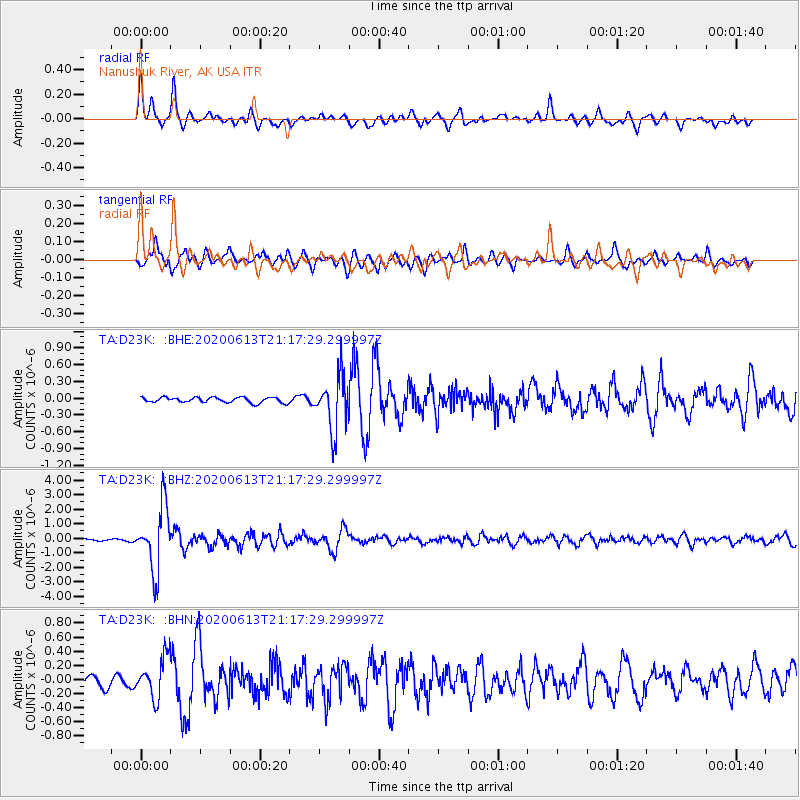
Signal To Noise
| Channel | StoN | STA | LTA |
| TA:D23K: :BHZ:20200613T21:17:29.299997Z | 32.02971 | 2.1446258E-6 | 6.69574E-8 |
| TA:D23K: :BHN:20200613T21:17:29.299997Z | 4.341908 | 2.924738E-7 | 6.7360666E-8 |
| TA:D23K: :BHE:20200613T21:17:29.299997Z | 10.256427 | 4.7671065E-7 | 4.6479215E-8 |
| Arrivals |
| Ps | 1.8 SECOND |
| PpPs | 5.6 SECOND |
| PsPs/PpSs | 7.3 SECOND |


