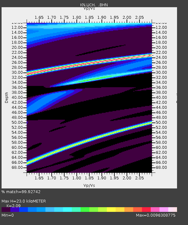
UCH KN.UCH - Earthquake Result Viewer
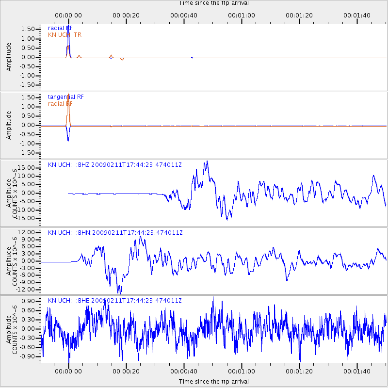
Earthquake location: Talaud Islands, Indonesia
Earthquake latitude/longitude: 3.9/126.4
Earthquake time(UTC): 2009/02/11 (042) 17:34:50 GMT
Earthquake Depth: 22 km
Earthquake Magnitude: 6.6 MB, 7.2 MS, 7.2 MW, 7.1 MW
Earthquake Catalog/Contributor: WHDF/NEIC
Network: KN Kyrgyz Seismic Telemetry Network
Station: UCH KN.UCH
Lat/Lon: 42.23 N/74.51 E
Elevation: 3850 m
Distance: 59.8 deg
Az: 317.479 deg
Baz: 114.782 deg
Ray Param: 0.061898965
Estimated Moho Depth: 23.0 km
Estimated Crust Vp/Vs: 2.09
Assumed Crust Vp: 6.306 km/s
Estimated Crust Vs: 3.017 km/s
Estimated Crust Poisson's Ratio: 0.35
Radial Match: 99.92742 %
Radial Bump: 12
Transverse Match: 98.80642 %
Transverse Bump: 101
SOD ConfigId: 2658
Insert Time: 2010-03-08 21:23:17.536 +0000
GWidth: 2.5
Max Bumps: 400
Tol: 0.001

Signal To Noise

ChannelStoNSTALTA
KN:UCH: :BHN:20090211T17:44:23.474011Z26.1019541.0708159E-64.1024357E-8
KN:UCH: :BHE:20090211T17:44:23.474011Z1.18556544.653807E-73.9253905E-7
KN:UCH: :BHZ:20090211T17:44:23.474011Z27.2818621.5064213E-65.5216955E-8
Arrivals
Ps4.1 SECOND
PpPs11 SECOND
PsPs/PpSs15 SECOND