You are here: Home > Network List > TA - USArray Transportable Network (new EarthScope stations) Stations List
> Station F31M Tsiigehtchic, NWT, CAN > Earthquake Result Viewer
F31M Tsiigehtchic, NWT, CAN - Earthquake Result Viewer
| Earthquake location: |
Mariana Islands |
| Earthquake latitude/longitude: |
18.9/145.1 |
| Earthquake time(UTC): |
2020/06/13 (165) 21:08:30 GMT |
| Earthquake Depth: |
622 km |
| Earthquake Magnitude: |
6.2 Mww |
| Earthquake Catalog/Contributor: |
NEIC PDE/us |
|
| Network: |
TA USArray Transportable Network (new EarthScope stations) |
| Station: |
F31M Tsiigehtchic, NWT, CAN |
| Lat/Lon: |
67.44 N/133.74 W |
| Elevation: |
56 m |
|
| Distance: |
69.3 deg |
| Az: |
24.054 deg |
| Baz: |
269.389 deg |
| Ray Param: |
0.053538363 |
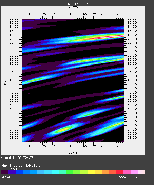
| Estimated Moho Depth: |
18.25 km |
| Estimated Crust Vp/Vs: |
2.08 |
| Assumed Crust Vp: |
6.171 km/s |
| Estimated Crust Vs: |
2.967 km/s |
| Estimated Crust Poisson's Ratio: |
0.35 |
|
| Radial Match: |
81.72437 % |
| Radial Bump: |
400 |
| Transverse Match: |
82.41833 % |
| Transverse Bump: |
384 |
| SOD ConfigId: |
21709731 |
| Insert Time: |
2020-06-27 21:28:30.704 +0000 |
| GWidth: |
2.5 |
| Max Bumps: |
400 |
| Tol: |
0.001 |
|
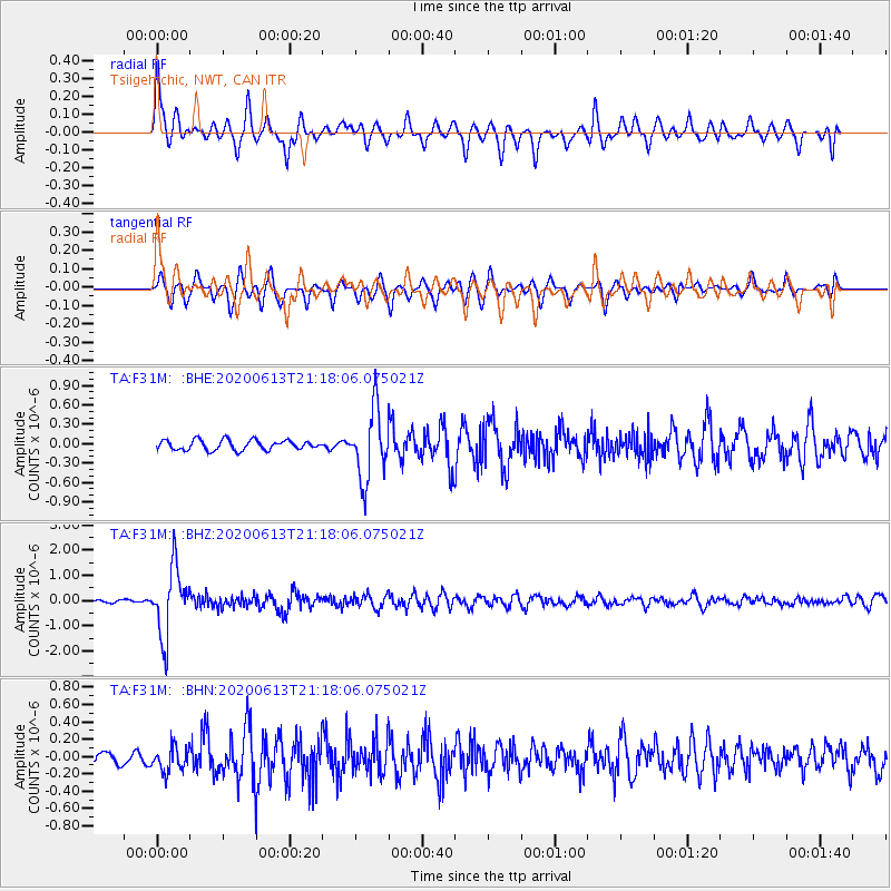
Signal To Noise
| Channel | StoN | STA | LTA |
| TA:F31M: :BHZ:20200613T21:18:06.075021Z | 19.925505 | 1.3239465E-6 | 6.644482E-8 |
| TA:F31M: :BHN:20200613T21:18:06.075021Z | 1.8812082 | 1.4118606E-7 | 7.505074E-8 |
| TA:F31M: :BHE:20200613T21:18:06.075021Z | 7.1154537 | 5.3763995E-7 | 7.555947E-8 |
| Arrivals |
| Ps | 3.3 SECOND |
| PpPs | 8.9 SECOND |
| PsPs/PpSs | 12 SECOND |


