You are here: Home > Network List > TA - USArray Transportable Network (new EarthScope stations) Stations List
> Station G23K Bananza Creek, AK, USA > Earthquake Result Viewer
G23K Bananza Creek, AK, USA - Earthquake Result Viewer

| Earthquake location: |
Mariana Islands |
| Earthquake latitude/longitude: |
18.9/145.1 |
| Earthquake time(UTC): |
2020/06/13 (165) 21:08:30 GMT |
| Earthquake Depth: |
622 km |
| Earthquake Magnitude: |
6.2 Mww |
| Earthquake Catalog/Contributor: |
NEIC PDE/us |
|
| Network: |
TA USArray Transportable Network (new EarthScope stations) |
| Station: |
G23K Bananza Creek, AK, USA |
| Lat/Lon: |
66.71 N/150.02 W |
| Elevation: |
746 m |
|
| Distance: |
62.9 deg |
| Az: |
23.854 deg |
| Baz: |
254.312 deg |
| Ray Param: |
0.05751383 |
| Estimated Moho Depth: |
33.75 km |
| Estimated Crust Vp/Vs: |
1.73 |
| Assumed Crust Vp: |
6.577 km/s |
| Estimated Crust Vs: |
3.807 km/s |
| Estimated Crust Poisson's Ratio: |
0.25 |
|
| Radial Match: |
90.0206 % |
| Radial Bump: |
272 |
| Transverse Match: |
79.60699 % |
| Transverse Bump: |
365 |
| SOD ConfigId: |
21709731 |
| Insert Time: |
2020-06-27 21:28:41.436 +0000 |
| GWidth: |
2.5 |
| Max Bumps: |
400 |
| Tol: |
0.001 |
|
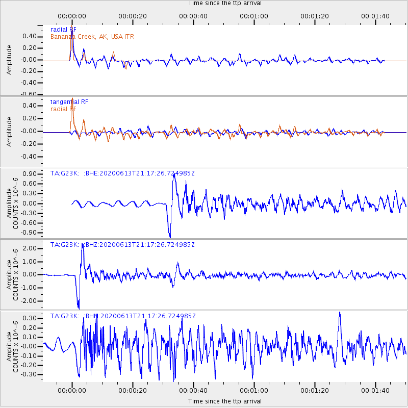
Signal To Noise
| Channel | StoN | STA | LTA |
| TA:G23K: :BHZ:20200613T21:17:26.724985Z | 17.23503 | 1.2436774E-6 | 7.2159864E-8 |
| TA:G23K: :BHN:20200613T21:17:26.724985Z | 3.7199228 | 1.5821621E-7 | 4.2532122E-8 |
| TA:G23K: :BHE:20200613T21:17:26.724985Z | 8.528876 | 5.2910855E-7 | 6.2037316E-8 |
| Arrivals |
| Ps | 3.9 SECOND |
| PpPs | 13 SECOND |
| PsPs/PpSs | 17 SECOND |


