You are here: Home > Network List > TA - USArray Transportable Network (new EarthScope stations) Stations List
> Station G31M Satah River, YT, CAN > Earthquake Result Viewer
G31M Satah River, YT, CAN - Earthquake Result Viewer
| Earthquake location: |
Mariana Islands |
| Earthquake latitude/longitude: |
18.9/145.1 |
| Earthquake time(UTC): |
2020/06/13 (165) 21:08:30 GMT |
| Earthquake Depth: |
622 km |
| Earthquake Magnitude: |
6.2 Mww |
| Earthquake Catalog/Contributor: |
NEIC PDE/us |
|
| Network: |
TA USArray Transportable Network (new EarthScope stations) |
| Station: |
G31M Satah River, YT, CAN |
| Lat/Lon: |
66.92 N/134.27 W |
| Elevation: |
61 m |
|
| Distance: |
69.1 deg |
| Az: |
24.608 deg |
| Baz: |
269.099 deg |
| Ray Param: |
0.05366206 |
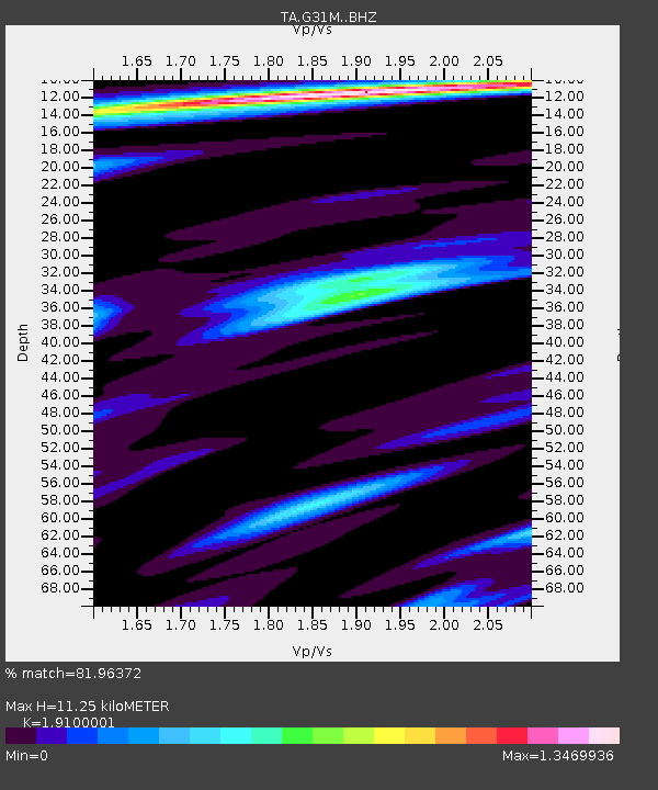
| Estimated Moho Depth: |
11.25 km |
| Estimated Crust Vp/Vs: |
1.91 |
| Assumed Crust Vp: |
6.171 km/s |
| Estimated Crust Vs: |
3.231 km/s |
| Estimated Crust Poisson's Ratio: |
0.31 |
|
| Radial Match: |
81.96372 % |
| Radial Bump: |
330 |
| Transverse Match: |
61.73442 % |
| Transverse Bump: |
369 |
| SOD ConfigId: |
21709731 |
| Insert Time: |
2020-06-27 21:28:49.827 +0000 |
| GWidth: |
2.5 |
| Max Bumps: |
400 |
| Tol: |
0.001 |
|

Signal To Noise
| Channel | StoN | STA | LTA |
| TA:G31M: :BHZ:20200613T21:18:04.825021Z | 20.314276 | 2.2980319E-6 | 1.1312399E-7 |
| TA:G31M: :BHN:20200613T21:18:04.825021Z | 1.2435901 | 1.8542298E-7 | 1.4910296E-7 |
| TA:G31M: :BHE:20200613T21:18:04.825021Z | 10.726542 | 9.573754E-7 | 8.9252936E-8 |
| Arrivals |
| Ps | 1.7 SECOND |
| PpPs | 5.1 SECOND |
| PsPs/PpSs | 6.9 SECOND |


