You are here: Home > Network List > TA - USArray Transportable Network (new EarthScope stations) Stations List
> Station H31M Peel River, Yukon, CAN > Earthquake Result Viewer
H31M Peel River, Yukon, CAN - Earthquake Result Viewer
| Earthquake location: |
Mariana Islands |
| Earthquake latitude/longitude: |
18.9/145.1 |
| Earthquake time(UTC): |
2020/06/13 (165) 21:08:30 GMT |
| Earthquake Depth: |
622 km |
| Earthquake Magnitude: |
6.2 Mww |
| Earthquake Catalog/Contributor: |
NEIC PDE/us |
|
| Network: |
TA USArray Transportable Network (new EarthScope stations) |
| Station: |
H31M Peel River, Yukon, CAN |
| Lat/Lon: |
65.81 N/134.34 W |
| Elevation: |
642 m |
|
| Distance: |
69.0 deg |
| Az: |
25.809 deg |
| Baz: |
269.463 deg |
| Ray Param: |
0.05368687 |
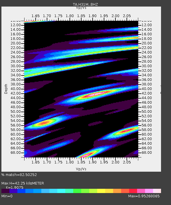
| Estimated Moho Depth: |
42.25 km |
| Estimated Crust Vp/Vs: |
1.91 |
| Assumed Crust Vp: |
6.419 km/s |
| Estimated Crust Vs: |
3.365 km/s |
| Estimated Crust Poisson's Ratio: |
0.31 |
|
| Radial Match: |
82.50252 % |
| Radial Bump: |
349 |
| Transverse Match: |
68.87368 % |
| Transverse Bump: |
362 |
| SOD ConfigId: |
21709731 |
| Insert Time: |
2020-06-27 21:29:01.578 +0000 |
| GWidth: |
2.5 |
| Max Bumps: |
400 |
| Tol: |
0.001 |
|
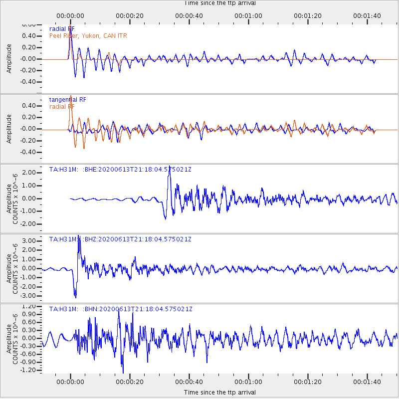
Signal To Noise
| Channel | StoN | STA | LTA |
| TA:H31M: :BHZ:20200613T21:18:04.575021Z | 23.556503 | 1.6526241E-6 | 7.015575E-8 |
| TA:H31M: :BHN:20200613T21:18:04.575021Z | 1.3890339 | 2.0008619E-7 | 1.4404701E-7 |
| TA:H31M: :BHE:20200613T21:18:04.575021Z | 13.845093 | 1.0945006E-6 | 7.905332E-8 |
| Arrivals |
| Ps | 6.2 SECOND |
| PpPs | 19 SECOND |
| PsPs/PpSs | 25 SECOND |


