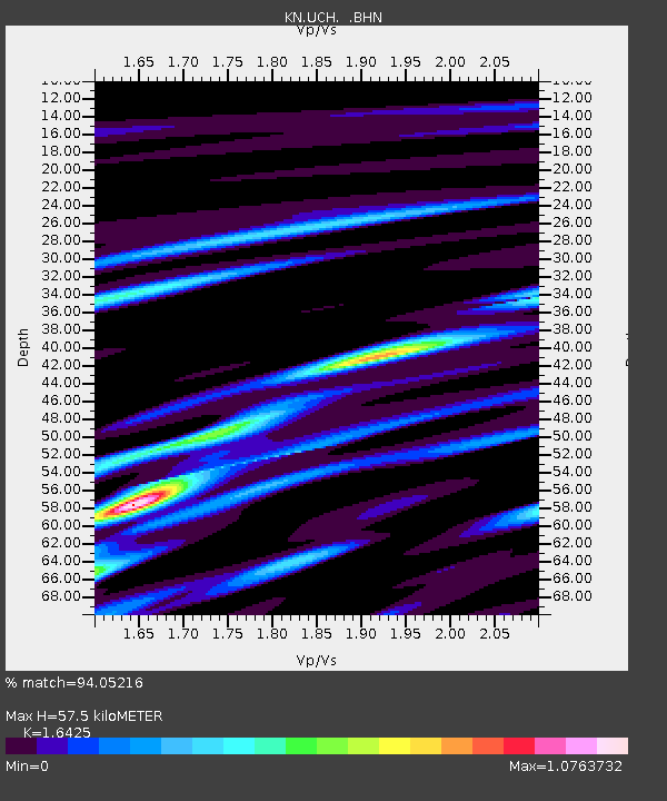
UCH KN.UCH - Earthquake Result Viewer
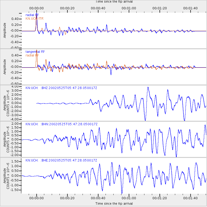
Earthquake location: South Of Alaska
Earthquake latitude/longitude: 53.8/-161.1
Earthquake time(UTC): 2002/05/25 (145) 05:36:31 GMT
Earthquake Depth: 33 km
Earthquake Magnitude: 5.5 MB, 6.1 MS, 6.5 MW, 6.4 MW
Earthquake Catalog/Contributor: WHDF/NEIC
Network: KN Kyrgyz Seismic Telemetry Network
Station: UCH KN.UCH
Lat/Lon: 42.23 N/74.51 E
Elevation: 3850 m
Distance: 73.1 deg
Az: 320.157 deg
Baz: 30.764 deg
Ray Param: 0.053172063
Estimated Moho Depth: 57.5 km
Estimated Crust Vp/Vs: 1.64
Assumed Crust Vp: 6.306 km/s
Estimated Crust Vs: 3.839 km/s
Estimated Crust Poisson's Ratio: 0.21
Radial Match: 94.05216 %
Radial Bump: 400
Transverse Match: 92.16202 %
Transverse Bump: 400
SOD ConfigId: 20082
Insert Time: 2010-03-08 21:23:31.630 +0000
GWidth: 2.5
Max Bumps: 400
Tol: 0.001

Signal To Noise

ChannelStoNSTALTA
KN:UCH: :BHN:20020525T05:47:28.050017Z2.1894538.3323954E-83.8056974E-8
KN:UCH: :BHE:20020525T05:47:28.050017Z1.17396574.3712838E-83.723519E-8
KN:UCH: :BHZ:20020525T05:47:28.050017Z3.06851362.1447167E-76.989432E-8
Arrivals
Ps6.1 SECOND
PpPs23 SECOND
PsPs/PpSs29 SECOND