You are here: Home > Network List > TA - USArray Transportable Network (new EarthScope stations) Stations List
> Station M18K Stony River, AK, USA > Earthquake Result Viewer
M18K Stony River, AK, USA - Earthquake Result Viewer
| Earthquake location: |
Mariana Islands |
| Earthquake latitude/longitude: |
18.9/145.1 |
| Earthquake time(UTC): |
2020/06/13 (165) 21:08:30 GMT |
| Earthquake Depth: |
622 km |
| Earthquake Magnitude: |
6.2 Mww |
| Earthquake Catalog/Contributor: |
NEIC PDE/us |
|
| Network: |
TA USArray Transportable Network (new EarthScope stations) |
| Station: |
M18K Stony River, AK, USA |
| Lat/Lon: |
61.49 N/155.82 W |
| Elevation: |
289 m |
|
| Distance: |
58.9 deg |
| Az: |
28.723 deg |
| Baz: |
251.465 deg |
| Ray Param: |
0.059949417 |
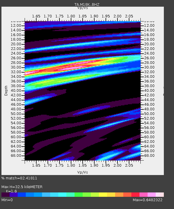
| Estimated Moho Depth: |
32.5 km |
| Estimated Crust Vp/Vs: |
1.60 |
| Assumed Crust Vp: |
6.566 km/s |
| Estimated Crust Vs: |
4.104 km/s |
| Estimated Crust Poisson's Ratio: |
0.18 |
|
| Radial Match: |
82.41811 % |
| Radial Bump: |
352 |
| Transverse Match: |
74.66756 % |
| Transverse Bump: |
397 |
| SOD ConfigId: |
21709731 |
| Insert Time: |
2020-06-27 21:29:34.230 +0000 |
| GWidth: |
2.5 |
| Max Bumps: |
400 |
| Tol: |
0.001 |
|

Signal To Noise
| Channel | StoN | STA | LTA |
| TA:M18K: :BHZ:20200613T21:17:00.824991Z | 16.490948 | 9.556725E-7 | 5.7951333E-8 |
| TA:M18K: :BHN:20200613T21:17:00.824991Z | 2.902639 | 1.7574696E-7 | 6.05473E-8 |
| TA:M18K: :BHE:20200613T21:17:00.824991Z | 7.668786 | 3.8232932E-7 | 4.9855263E-8 |
| Arrivals |
| Ps | 3.1 SECOND |
| PpPs | 12 SECOND |
| PsPs/PpSs | 15 SECOND |


