You are here: Home > Network List > TA - USArray Transportable Network (new EarthScope stations) Stations List
> Station M22K Willow, AK, USA > Earthquake Result Viewer
M22K Willow, AK, USA - Earthquake Result Viewer
| Earthquake location: |
Mariana Islands |
| Earthquake latitude/longitude: |
18.9/145.1 |
| Earthquake time(UTC): |
2020/06/13 (165) 21:08:30 GMT |
| Earthquake Depth: |
622 km |
| Earthquake Magnitude: |
6.2 Mww |
| Earthquake Catalog/Contributor: |
NEIC PDE/us |
|
| Network: |
TA USArray Transportable Network (new EarthScope stations) |
| Station: |
M22K Willow, AK, USA |
| Lat/Lon: |
61.75 N/150.12 W |
| Elevation: |
57 m |
|
| Distance: |
61.6 deg |
| Az: |
29.29 deg |
| Baz: |
256.758 deg |
| Ray Param: |
0.0583061 |
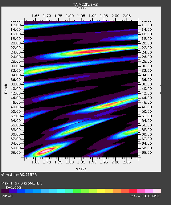
| Estimated Moho Depth: |
67.0 km |
| Estimated Crust Vp/Vs: |
1.70 |
| Assumed Crust Vp: |
6.302 km/s |
| Estimated Crust Vs: |
3.718 km/s |
| Estimated Crust Poisson's Ratio: |
0.23 |
|
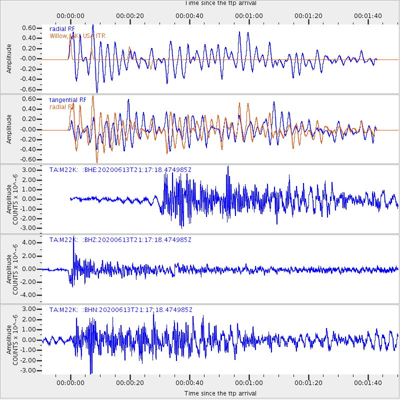
| Radial Match: |
80.71573 % |
| Radial Bump: |
400 |
| Transverse Match: |
73.481575 % |
| Transverse Bump: |
400 |
| SOD ConfigId: |
21709731 |
| Insert Time: |
2020-06-27 21:29:37.248 +0000 |
| GWidth: |
2.5 |
| Max Bumps: |
400 |
| Tol: |
0.001 |
|
Signal To Noise
| Channel | StoN | STA | LTA |
| TA:M22K: :BHZ:20200613T21:17:18.474985Z | 16.50591 | 1.441088E-6 | 8.730739E-8 |
| TA:M22K: :BHN:20200613T21:17:18.474985Z | 4.774102 | 7.02644E-7 | 1.4717824E-7 |
| TA:M22K: :BHE:20200613T21:17:18.474985Z | 8.539182 | 1.2157661E-6 | 1.4237501E-7 |
| Arrivals |
| Ps | 7.7 SECOND |
| PpPs | 27 SECOND |
| PsPs/PpSs | 35 SECOND |


