You are here: Home > Network List > TS - TERRAscope (Southern California Seismic Network) Stations List
> Station VTV Victorville, California, USA > Earthquake Result Viewer
VTV Victorville, California, USA - Earthquake Result Viewer

| Earthquake location: |
Near Coast Of Central Chile |
| Earthquake latitude/longitude: |
-30.1/-71.9 |
| Earthquake time(UTC): |
1997/07/06 (187) 09:54:00 GMT |
| Earthquake Depth: |
19 km |
| Earthquake Magnitude: |
5.8 MB, 6.5 MS, 6.8 UNKNOWN, 6.4 ME |
| Earthquake Catalog/Contributor: |
WHDF/NEIC |
|
| Network: |
TS TERRAscope (Southern California Seismic Network) |
| Station: |
VTV Victorville, California, USA |
| Lat/Lon: |
34.57 N/117.33 W |
| Elevation: |
847 m |
|
| Distance: |
77.3 deg |
| Az: |
322.913 deg |
| Baz: |
140.689 deg |
| Ray Param: |
0.050419413 |
| Estimated Moho Depth: |
26.5 km |
| Estimated Crust Vp/Vs: |
1.86 |
| Assumed Crust Vp: |
6.276 km/s |
| Estimated Crust Vs: |
3.37 km/s |
| Estimated Crust Poisson's Ratio: |
0.30 |
|
| Radial Match: |
87.247475 % |
| Radial Bump: |
400 |
| Transverse Match: |
73.025085 % |
| Transverse Bump: |
400 |
| SOD ConfigId: |
6273 |
| Insert Time: |
2010-02-26 14:54:29.814 +0000 |
| GWidth: |
2.5 |
| Max Bumps: |
400 |
| Tol: |
0.001 |
|
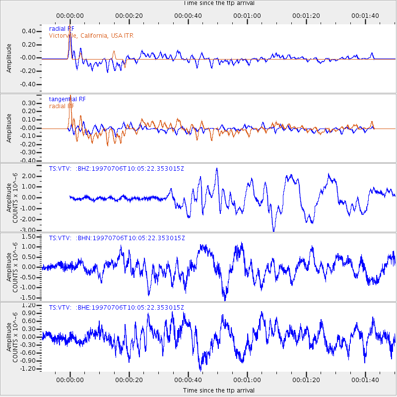
Signal To Noise
| Channel | StoN | STA | LTA |
| TS:VTV: :BHN:19970706T10:05:22.353015Z | 1.7514544 | 2.032886E-7 | 1.16068456E-7 |
| TS:VTV: :BHE:19970706T10:05:22.353015Z | 1.2307845 | 1.6397911E-7 | 1.3323138E-7 |
| TS:VTV: :BHZ:19970706T10:05:22.353015Z | 3.028728 | 3.3867832E-7 | 1.1182197E-7 |
| Arrivals |
| Ps | 3.7 SECOND |
| PpPs | 12 SECOND |
| PsPs/PpSs | 16 SECOND |


