You are here: Home > Network List > TA - USArray Transportable Network (new EarthScope stations) Stations List
> Station N31M Braeburn, Yukon, CA > Earthquake Result Viewer
N31M Braeburn, Yukon, CA - Earthquake Result Viewer
| Earthquake location: |
Mariana Islands |
| Earthquake latitude/longitude: |
18.9/145.1 |
| Earthquake time(UTC): |
2020/06/13 (165) 21:08:30 GMT |
| Earthquake Depth: |
622 km |
| Earthquake Magnitude: |
6.2 Mww |
| Earthquake Catalog/Contributor: |
NEIC PDE/us |
|
| Network: |
TA USArray Transportable Network (new EarthScope stations) |
| Station: |
N31M Braeburn, Yukon, CA |
| Lat/Lon: |
61.49 N/135.78 W |
| Elevation: |
716 m |
|
| Distance: |
68.4 deg |
| Az: |
30.46 deg |
| Baz: |
269.867 deg |
| Ray Param: |
0.054118726 |
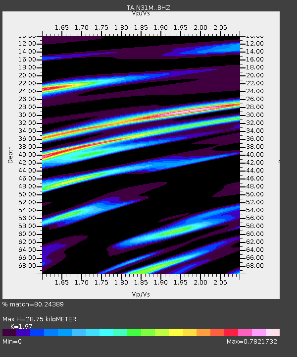
| Estimated Moho Depth: |
28.75 km |
| Estimated Crust Vp/Vs: |
1.97 |
| Assumed Crust Vp: |
6.419 km/s |
| Estimated Crust Vs: |
3.258 km/s |
| Estimated Crust Poisson's Ratio: |
0.33 |
|
| Radial Match: |
80.24389 % |
| Radial Bump: |
400 |
| Transverse Match: |
73.11886 % |
| Transverse Bump: |
400 |
| SOD ConfigId: |
21709731 |
| Insert Time: |
2020-06-27 21:29:52.095 +0000 |
| GWidth: |
2.5 |
| Max Bumps: |
400 |
| Tol: |
0.001 |
|

Signal To Noise
| Channel | StoN | STA | LTA |
| TA:N31M: :BHZ:20200613T21:18:00.575021Z | 10.8978405 | 1.3688219E-6 | 1.2560488E-7 |
| TA:N31M: :BHN:20200613T21:18:00.575021Z | 2.988074 | 2.338715E-7 | 7.826831E-8 |
| TA:N31M: :BHE:20200613T21:18:00.575021Z | 6.5207696 | 6.9727406E-7 | 1.0693125E-7 |
| Arrivals |
| Ps | 4.5 SECOND |
| PpPs | 13 SECOND |
| PsPs/PpSs | 17 SECOND |


