You are here: Home > Network List > TA - USArray Transportable Network (new EarthScope stations) Stations List
> Station P29M Windy Craggy, BC, CAN > Earthquake Result Viewer
P29M Windy Craggy, BC, CAN - Earthquake Result Viewer
| Earthquake location: |
Mariana Islands |
| Earthquake latitude/longitude: |
18.9/145.1 |
| Earthquake time(UTC): |
2020/06/13 (165) 21:08:30 GMT |
| Earthquake Depth: |
622 km |
| Earthquake Magnitude: |
6.2 Mww |
| Earthquake Catalog/Contributor: |
NEIC PDE/us |
|
| Network: |
TA USArray Transportable Network (new EarthScope stations) |
| Station: |
P29M Windy Craggy, BC, CAN |
| Lat/Lon: |
59.63 N/137.74 W |
| Elevation: |
679 m |
|
| Distance: |
67.4 deg |
| Az: |
32.459 deg |
| Baz: |
268.917 deg |
| Ray Param: |
0.054729324 |
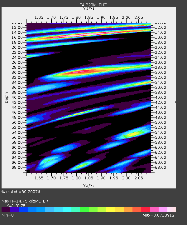
| Estimated Moho Depth: |
14.75 km |
| Estimated Crust Vp/Vs: |
1.82 |
| Assumed Crust Vp: |
6.566 km/s |
| Estimated Crust Vs: |
3.613 km/s |
| Estimated Crust Poisson's Ratio: |
0.28 |
|
| Radial Match: |
80.20076 % |
| Radial Bump: |
400 |
| Transverse Match: |
68.7033 % |
| Transverse Bump: |
400 |
| SOD ConfigId: |
21709731 |
| Insert Time: |
2020-06-27 21:30:04.638 +0000 |
| GWidth: |
2.5 |
| Max Bumps: |
400 |
| Tol: |
0.001 |
|
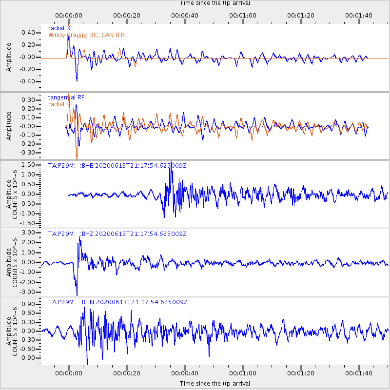
Signal To Noise
| Channel | StoN | STA | LTA |
| TA:P29M: :BHZ:20200613T21:17:54.625009Z | 11.763847 | 1.2959571E-6 | 1.10164386E-7 |
| TA:P29M: :BHN:20200613T21:17:54.625009Z | 2.5860496 | 2.3729667E-7 | 9.17603E-8 |
| TA:P29M: :BHE:20200613T21:17:54.625009Z | 6.943504 | 4.6392006E-7 | 6.681354E-8 |
| Arrivals |
| Ps | 1.9 SECOND |
| PpPs | 6.1 SECOND |
| PsPs/PpSs | 8.0 SECOND |


