You are here: Home > Network List > TJ - Tajikistan National Seismic Network Stations List
> Station SHAA Shaartuz, Tajikistan > Earthquake Result Viewer
SHAA Shaartuz, Tajikistan - Earthquake Result Viewer
| Earthquake location: |
Mariana Islands |
| Earthquake latitude/longitude: |
18.9/145.1 |
| Earthquake time(UTC): |
2020/06/13 (165) 21:08:30 GMT |
| Earthquake Depth: |
622 km |
| Earthquake Magnitude: |
6.2 Mww |
| Earthquake Catalog/Contributor: |
NEIC PDE/us |
|
| Network: |
TJ Tajikistan National Seismic Network |
| Station: |
SHAA Shaartuz, Tajikistan |
| Lat/Lon: |
37.56 N/68.12 E |
| Elevation: |
868 m |
|
| Distance: |
68.6 deg |
| Az: |
303.728 deg |
| Baz: |
82.165 deg |
| Ray Param: |
0.053975362 |
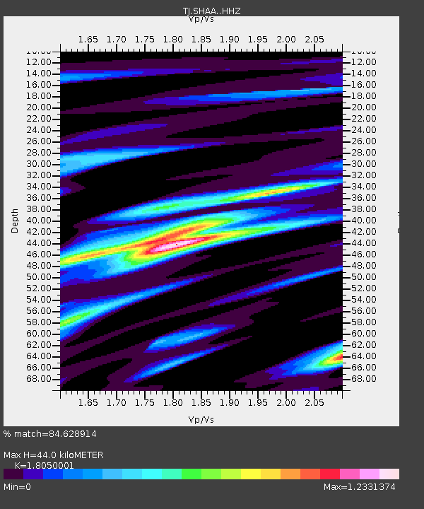
| Estimated Moho Depth: |
44.0 km |
| Estimated Crust Vp/Vs: |
1.81 |
| Assumed Crust Vp: |
6.213 km/s |
| Estimated Crust Vs: |
3.442 km/s |
| Estimated Crust Poisson's Ratio: |
0.28 |
|
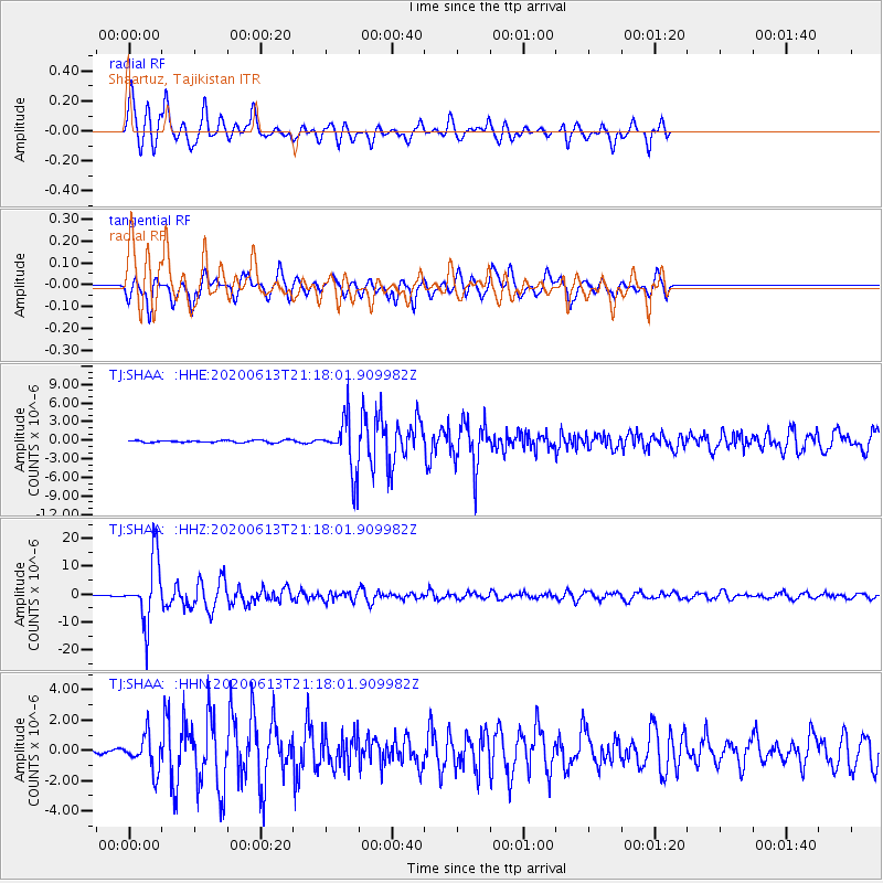
| Radial Match: |
84.628914 % |
| Radial Bump: |
400 |
| Transverse Match: |
82.61146 % |
| Transverse Bump: |
339 |
| SOD ConfigId: |
21709731 |
| Insert Time: |
2020-06-27 21:30:42.654 +0000 |
| GWidth: |
2.5 |
| Max Bumps: |
400 |
| Tol: |
0.001 |
|
Signal To Noise
| Channel | StoN | STA | LTA |
| TJ:SHAA: :HHZ:20200613T21:18:01.909982Z | 55.52244 | 1.1378484E-5 | 2.0493485E-7 |
| TJ:SHAA: :HHN:20200613T21:18:01.909982Z | 14.196956 | 1.1507165E-6 | 8.105375E-8 |
| TJ:SHAA: :HHE:20200613T21:18:01.909982Z | 23.615633 | 4.1719786E-6 | 1.7666173E-7 |
| Arrivals |
| Ps | 5.9 SECOND |
| PpPs | 19 SECOND |
| PsPs/PpSs | 25 SECOND |


