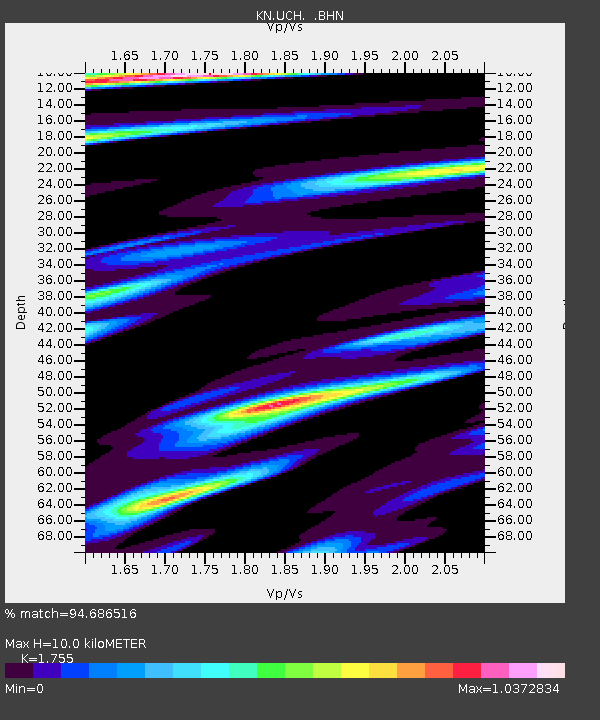
UCH KN.UCH - Earthquake Result Viewer
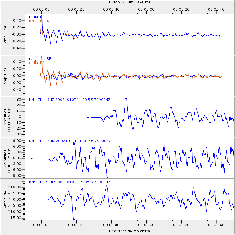
Earthquake location: Irian Jaya Region, Indonesia
Earthquake latitude/longitude: -1.8/134.3
Earthquake time(UTC): 2002/10/10 (283) 10:50:20 GMT
Earthquake Depth: 10 km
Earthquake Magnitude: 6.5 MB, 7.7 MS, 7.6 MW, 7.4 MW
Earthquake Catalog/Contributor: WHDF/NEIC
Network: KN Kyrgyz Seismic Telemetry Network
Station: UCH KN.UCH
Lat/Lon: 42.23 N/74.51 E
Elevation: 3850 m
Distance: 69.3 deg
Az: 316.683 deg
Baz: 112.595 deg
Ray Param: 0.05572874
Estimated Moho Depth: 10.0 km
Estimated Crust Vp/Vs: 1.75
Assumed Crust Vp: 6.306 km/s
Estimated Crust Vs: 3.593 km/s
Estimated Crust Poisson's Ratio: 0.26
Radial Match: 94.686516 %
Radial Bump: 400
Transverse Match: 80.90794 %
Transverse Bump: 400
SOD ConfigId: 4714
Insert Time: 2010-03-08 21:24:11.010 +0000
GWidth: 2.5
Max Bumps: 400
Tol: 0.001

Signal To Noise

ChannelStoNSTALTA
KN:UCH: :BHN:20021010T11:00:56.799004Z2.43232371.7769307E-77.305486E-8
KN:UCH: :BHE:20021010T11:00:56.799004Z7.8783653.5818053E-74.5463818E-8
KN:UCH: :BHZ:20021010T11:00:56.799004Z17.2629858.8916244E-75.1506873E-8
Arrivals
Ps1.2 SECOND
PpPs4.2 SECOND
PsPs/PpSs5.5 SECOND