You are here: Home > Network List > UU - University of Utah Regional Network Stations List
> Station HVU Hansel Valley, UT, USA > Earthquake Result Viewer
HVU Hansel Valley, UT, USA - Earthquake Result Viewer
| Earthquake location: |
Mariana Islands |
| Earthquake latitude/longitude: |
18.9/145.1 |
| Earthquake time(UTC): |
2020/06/13 (165) 21:08:30 GMT |
| Earthquake Depth: |
622 km |
| Earthquake Magnitude: |
6.2 Mww |
| Earthquake Catalog/Contributor: |
NEIC PDE/us |
|
| Network: |
UU University of Utah Regional Network |
| Station: |
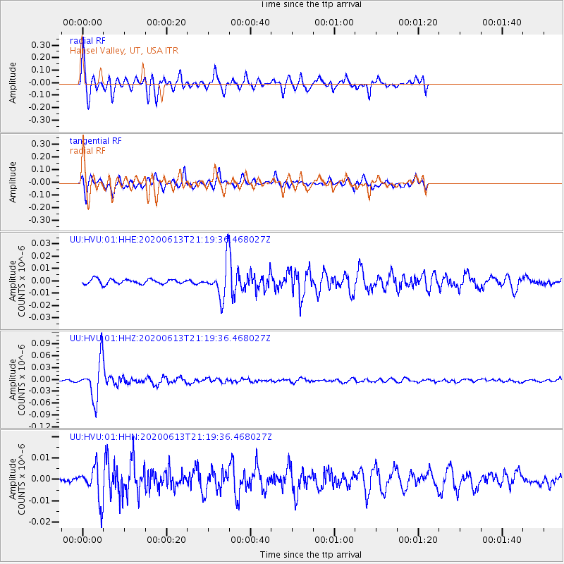
HVU Hansel Valley, UT, USA |
| Lat/Lon: |
41.78 N/112.78 W |
| Elevation: |
1609 m |
|
| Distance: |
86.2 deg |
| Az: |
47.126 deg |
| Baz: |
291.954 deg |
| Ray Param: |
0.042362545 |
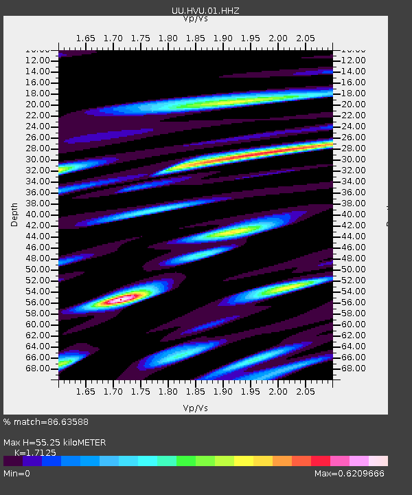
| Estimated Moho Depth: |
55.25 km |
| Estimated Crust Vp/Vs: |
1.71 |
| Assumed Crust Vp: |
6.276 km/s |
| Estimated Crust Vs: |
3.665 km/s |
| Estimated Crust Poisson's Ratio: |
0.24 |
|
| Radial Match: |
86.63588 % |
| Radial Bump: |
384 |
| Transverse Match: |
81.054276 % |
| Transverse Bump: |
358 |
| SOD ConfigId: |
21709731 |
| Insert Time: |
2020-06-27 21:32:38.729 +0000 |
| GWidth: |
2.5 |
| Max Bumps: |
400 |
| Tol: |
0.001 |
|
Signal To Noise
| Channel | StoN | STA | LTA |
| UU:HVU:01:HHZ:20200613T21:19:36.468027Z | 22.74812 | 5.002521E-8 | 2.199092E-9 |
| UU:HVU:01:HHN:20200613T21:19:36.468027Z | 5.9978323 | 7.846937E-9 | 1.3082956E-9 |
| UU:HVU:01:HHE:20200613T21:19:36.468027Z | 7.3394837 | 1.420374E-8 | 1.9352506E-9 |
| Arrivals |
| Ps | 6.4 SECOND |
| PpPs | 23 SECOND |
| PsPs/PpSs | 30 SECOND |


