You are here: Home > Network List > KN - Kyrgyz Seismic Telemetry Network Stations List
> Station UCH KN.UCH > Earthquake Result Viewer
UCH KN.UCH - Earthquake Result Viewer
| Earthquake location: |
Talaud Islands, Indonesia |
| Earthquake latitude/longitude: |
3.9/126.6 |
| Earthquake time(UTC): |
2009/02/11 (042) 17:44:04 GMT |
| Earthquake Depth: |
29 km |
| Earthquake Magnitude: |
5.5 MB |
| Earthquake Catalog/Contributor: |
WHDF/NEIC |
|
| Network: |
KN Kyrgyz Seismic Telemetry Network |
| Station: |
UCH KN.UCH |
| Lat/Lon: |
42.23 N/74.51 E |
| Elevation: |
3850 m |
|
| Distance: |
60.0 deg |
| Az: |
317.394 deg |
| Baz: |
114.58 deg |
| Ray Param: |
0.061768018 |
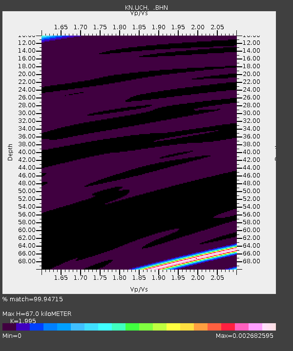
| Estimated Moho Depth: |
67.0 km |
| Estimated Crust Vp/Vs: |
2.00 |
| Assumed Crust Vp: |
6.306 km/s |
| Estimated Crust Vs: |
3.161 km/s |
| Estimated Crust Poisson's Ratio: |
0.33 |
|
| Radial Match: |
99.94715 % |
| Radial Bump: |
4 |
| Transverse Match: |
99.02911 % |
| Transverse Bump: |
43 |
| SOD ConfigId: |
2658 |
| Insert Time: |
2010-03-08 21:24:16.246 +0000 |
| GWidth: |
2.5 |
| Max Bumps: |
400 |
| Tol: |
0.001 |
|

Signal To Noise
| Channel | StoN | STA | LTA |
| KN:UCH: :BHN:20090211T17:53:37.650029Z | 1.4106216 | 7.2774837E-6 | 5.1590614E-6 |
| KN:UCH: :BHE:20090211T17:53:37.650029Z | 0.9815623 | 3.392438E-7 | 3.4561614E-7 |
| KN:UCH: :BHZ:20090211T17:53:37.650029Z | 1.4101434 | 1.0266655E-5 | 7.280575E-6 |
| Arrivals |
| Ps | 11 SECOND |
| PpPs | 31 SECOND |
| PsPs/PpSs | 42 SECOND |


