You are here: Home > Network List > UW - Pacific Northwest Regional Seismic Network Stations List
> Station IRON Crane, OR, USA > Earthquake Result Viewer
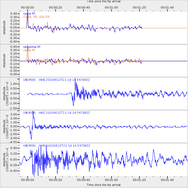
IRON Crane, OR, USA - Earthquake Result Viewer
*The percent match for this event was below the threshold and hence no stack was calculated.
| Earthquake location: |
Mariana Islands |
| Earthquake latitude/longitude: |
18.9/145.1 |
| Earthquake time(UTC): |
2020/06/13 (165) 21:08:30 GMT |
| Earthquake Depth: |
622 km |
| Earthquake Magnitude: |
6.2 Mww |
| Earthquake Catalog/Contributor: |
NEIC PDE/us |
|
| Network: |
UW Pacific Northwest Regional Seismic Network |
| Station: |
IRON Crane, OR, USA |
| Lat/Lon: |
43.36 N/118.47 W |
| Elevation: |
1226 m |
|
| Distance: |
81.7 deg |
| Az: |
47.087 deg |
| Baz: |
288.106 deg |
| Ray Param: |
$rayparam |
*The percent match for this event was below the threshold and hence was not used in the summary stack. |
|
| Radial Match: |
75.77422 % |
| Radial Bump: |
320 |
| Transverse Match: |
56.44944 % |
| Transverse Bump: |
400 |
| SOD ConfigId: |
21709731 |
| Insert Time: |
2020-06-27 21:33:38.671 +0000 |
| GWidth: |
2.5 |
| Max Bumps: |
400 |
| Tol: |
0.001 |
|
Signal To Noise
| Channel | StoN | STA | LTA |
| UW:IRON: :HHZ:20200613T21:19:14.547983Z | 19.653261 | 1.6564942E-6 | 8.428597E-8 |
| UW:IRON: :HHN:20200613T21:19:14.547983Z | 2.7211459 | 2.1642002E-7 | 7.9532676E-8 |
| UW:IRON: :HHE:20200613T21:19:14.547983Z | 12.936783 | 5.5883646E-7 | 4.319748E-8 |
| Arrivals |
| Ps | |
| PpPs | |
| PsPs/PpSs | |


