You are here: Home > Network List > BK - Berkeley Digital Seismograph Network Stations List
> Station HUMO Hull Mountain, OR > Earthquake Result Viewer
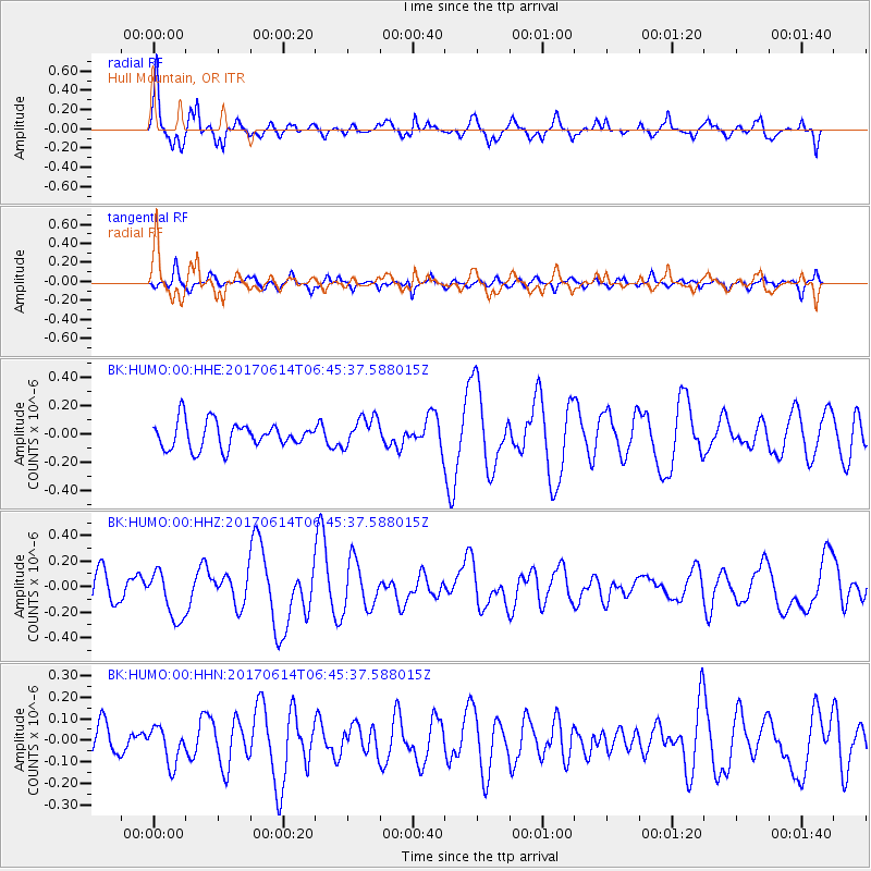
HUMO Hull Mountain, OR - Earthquake Result Viewer
*The percent match for this event was below the threshold and hence no stack was calculated.
| Earthquake location: |
Near Coast Of Chiapas, Mexico |
| Earthquake latitude/longitude: |
14.2/-93.2 |
| Earthquake time(UTC): |
2017/06/14 (165) 06:38:48 GMT |
| Earthquake Depth: |
11 km |
| Earthquake Magnitude: |
5.5 Mww |
| Earthquake Catalog/Contributor: |
NEIC PDE/us |
|
| Network: |
BK Berkeley Digital Seismograph Network |
| Station: |
HUMO Hull Mountain, OR |
| Lat/Lon: |
42.61 N/122.96 W |
| Elevation: |
555 m |
|
| Distance: |
38.2 deg |
| Az: |
323.595 deg |
| Baz: |
128.781 deg |
| Ray Param: |
$rayparam |
*The percent match for this event was below the threshold and hence was not used in the summary stack. |
|
| Radial Match: |
79.4525 % |
| Radial Bump: |
400 |
| Transverse Match: |
65.82049 % |
| Transverse Bump: |
400 |
| SOD ConfigId: |
2140511 |
| Insert Time: |
2017-06-27 22:30:29.605 +0000 |
| GWidth: |
2.5 |
| Max Bumps: |
400 |
| Tol: |
0.001 |
|
Signal To Noise
| Channel | StoN | STA | LTA |
| BK:HUMO:00:HHZ:20170614T06:45:37.588015Z | 1.9134907 | 1.895286E-7 | 9.904862E-8 |
| BK:HUMO:00:HHN:20170614T06:45:37.588015Z | 1.410539 | 8.404708E-8 | 5.958508E-8 |
| BK:HUMO:00:HHE:20170614T06:45:37.588015Z | 1.1618599 | 1.06257325E-7 | 9.145451E-8 |
| Arrivals |
| Ps | |
| PpPs | |
| PsPs/PpSs | |


