You are here: Home > Network List > G - GEOSCOPE Stations List
> Station MPG Montagne des Peres, French Guyana > Earthquake Result Viewer
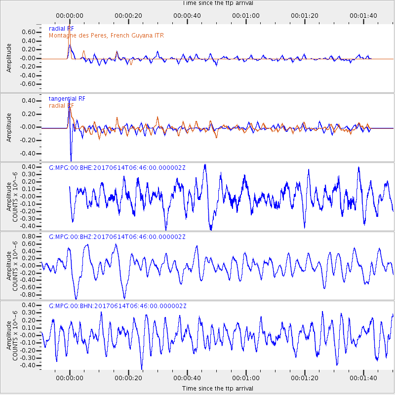
MPG Montagne des Peres, French Guyana - Earthquake Result Viewer
*The percent match for this event was below the threshold and hence no stack was calculated.
| Earthquake location: |
Near Coast Of Chiapas, Mexico |
| Earthquake latitude/longitude: |
14.2/-93.2 |
| Earthquake time(UTC): |
2017/06/14 (165) 06:38:48 GMT |
| Earthquake Depth: |
11 km |
| Earthquake Magnitude: |
5.5 Mww |
| Earthquake Catalog/Contributor: |
NEIC PDE/us |
|
| Network: |
G GEOSCOPE |
| Station: |
MPG Montagne des Peres, French Guyana |
| Lat/Lon: |
5.11 N/52.64 W |
| Elevation: |
147 m |
|
| Distance: |
40.9 deg |
| Az: |
98.711 deg |
| Baz: |
285.779 deg |
| Ray Param: |
$rayparam |
*The percent match for this event was below the threshold and hence was not used in the summary stack. |
|
| Radial Match: |
72.26427 % |
| Radial Bump: |
400 |
| Transverse Match: |
64.1313 % |
| Transverse Bump: |
400 |
| SOD ConfigId: |
2140511 |
| Insert Time: |
2017-06-27 22:30:55.021 +0000 |
| GWidth: |
2.5 |
| Max Bumps: |
400 |
| Tol: |
0.001 |
|
Signal To Noise
| Channel | StoN | STA | LTA |
| G:MPG:00:BHZ:20170614T06:46:00.000002Z | 4.707932 | 4.9461755E-7 | 1.0506047E-7 |
| G:MPG:00:BHN:20170614T06:46:00.000002Z | 1.0797272 | 1.10279515E-7 | 1.0213646E-7 |
| G:MPG:00:BHE:20170614T06:46:00.000002Z | 1.4493284 | 1.821343E-7 | 1.2566807E-7 |
| Arrivals |
| Ps | |
| PpPs | |
| PsPs/PpSs | |


