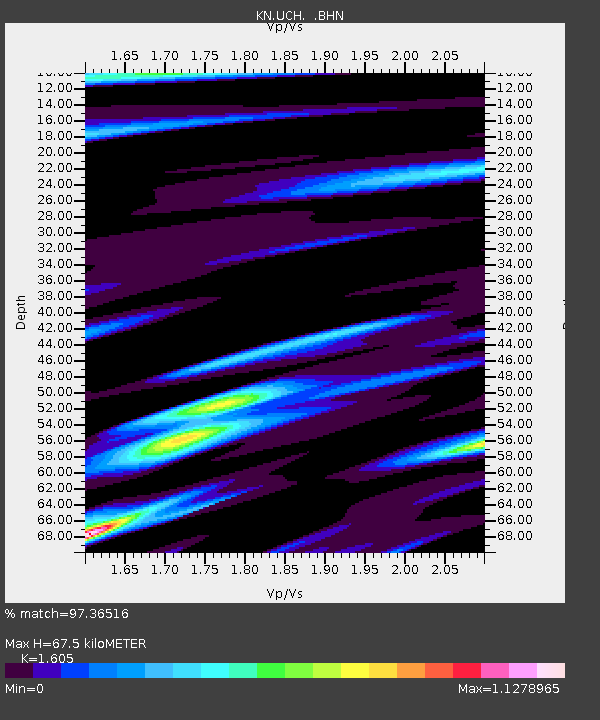
UCH KN.UCH - Earthquake Result Viewer
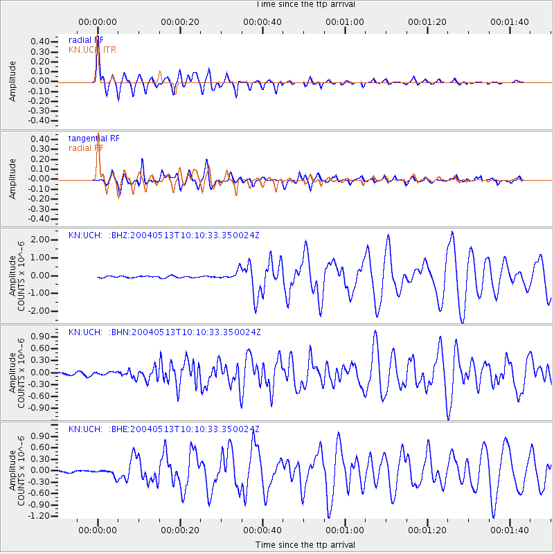
Earthquake location: New Ireland Region, P.N.G.
Earthquake latitude/longitude: -3.6/150.7
Earthquake time(UTC): 2004/05/13 (134) 09:58:43 GMT
Earthquake Depth: 10 km
Earthquake Magnitude: 5.8 MB, 6.3 MS, 6.3 MW, 6.2 MW
Earthquake Catalog/Contributor: WHDF/NEIC
Network: KN Kyrgyz Seismic Telemetry Network
Station: UCH KN.UCH
Lat/Lon: 42.23 N/74.51 E
Elevation: 3850 m
Distance: 82.2 deg
Az: 313.281 deg
Baz: 101.961 deg
Ray Param: 0.04702497
Estimated Moho Depth: 67.5 km
Estimated Crust Vp/Vs: 1.61
Assumed Crust Vp: 6.306 km/s
Estimated Crust Vs: 3.929 km/s
Estimated Crust Poisson's Ratio: 0.18
Radial Match: 97.36516 %
Radial Bump: 400
Transverse Match: 92.0449 %
Transverse Bump: 400
SOD ConfigId: 2459
Insert Time: 2010-03-08 21:25:11.398 +0000
GWidth: 2.5
Max Bumps: 400
Tol: 0.001

Signal To Noise

ChannelStoNSTALTA
KN:UCH: :BHN:20040513T10:10:33.350024Z1.54126053.8945803E-82.52688E-8
KN:UCH: :BHE:20040513T10:10:33.350024Z4.0380759.810651E-82.4295366E-8
KN:UCH: :BHZ:20040513T10:10:33.350024Z5.73659942.6402586E-74.6024798E-8
Arrivals
Ps6.7 SECOND
PpPs27 SECOND
PsPs/PpSs34 SECOND