You are here: Home > Network List > IW - Intermountain West Stations List
> Station DLMT Dillon, Montana, USA > Earthquake Result Viewer
DLMT Dillon, Montana, USA - Earthquake Result Viewer

| Earthquake location: |
Near Coast Of Chiapas, Mexico |
| Earthquake latitude/longitude: |
14.2/-93.2 |
| Earthquake time(UTC): |
2017/06/14 (165) 06:38:48 GMT |
| Earthquake Depth: |
11 km |
| Earthquake Magnitude: |
5.5 Mww |
| Earthquake Catalog/Contributor: |
NEIC PDE/us |
|
| Network: |
IW Intermountain West |
| Station: |
DLMT Dillon, Montana, USA |
| Lat/Lon: |
45.36 N/112.60 W |
| Elevation: |
1569 m |
|
| Distance: |
35.1 deg |
| Az: |
335.929 deg |
| Baz: |
145.874 deg |
| Ray Param: |
0.07738168 |
| Estimated Moho Depth: |
30.75 km |
| Estimated Crust Vp/Vs: |
1.92 |
| Assumed Crust Vp: |
6.577 km/s |
| Estimated Crust Vs: |
3.421 km/s |
| Estimated Crust Poisson's Ratio: |
0.31 |
|
| Radial Match: |
88.49342 % |
| Radial Bump: |
400 |
| Transverse Match: |
79.87974 % |
| Transverse Bump: |
400 |
| SOD ConfigId: |
2140511 |
| Insert Time: |
2017-06-27 22:31:49.349 +0000 |
| GWidth: |
2.5 |
| Max Bumps: |
400 |
| Tol: |
0.001 |
|
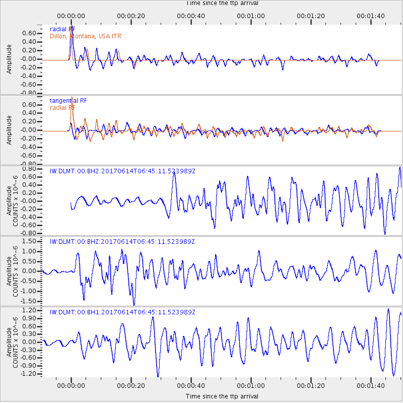
Signal To Noise
| Channel | StoN | STA | LTA |
| IW:DLMT:00:BHZ:20170614T06:45:11.523989Z | 9.780884 | 6.250445E-7 | 6.390471E-8 |
| IW:DLMT:00:BH1:20170614T06:45:11.523989Z | 2.800989 | 2.80248E-7 | 1.00053235E-7 |
| IW:DLMT:00:BH2:20170614T06:45:11.523989Z | 4.2560463 | 3.31458E-7 | 7.787933E-8 |
| Arrivals |
| Ps | 4.6 SECOND |
| PpPs | 13 SECOND |
| PsPs/PpSs | 17 SECOND |


