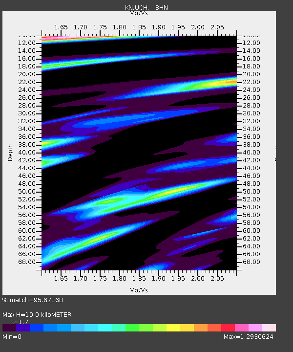
UCH KN.UCH - Earthquake Result Viewer
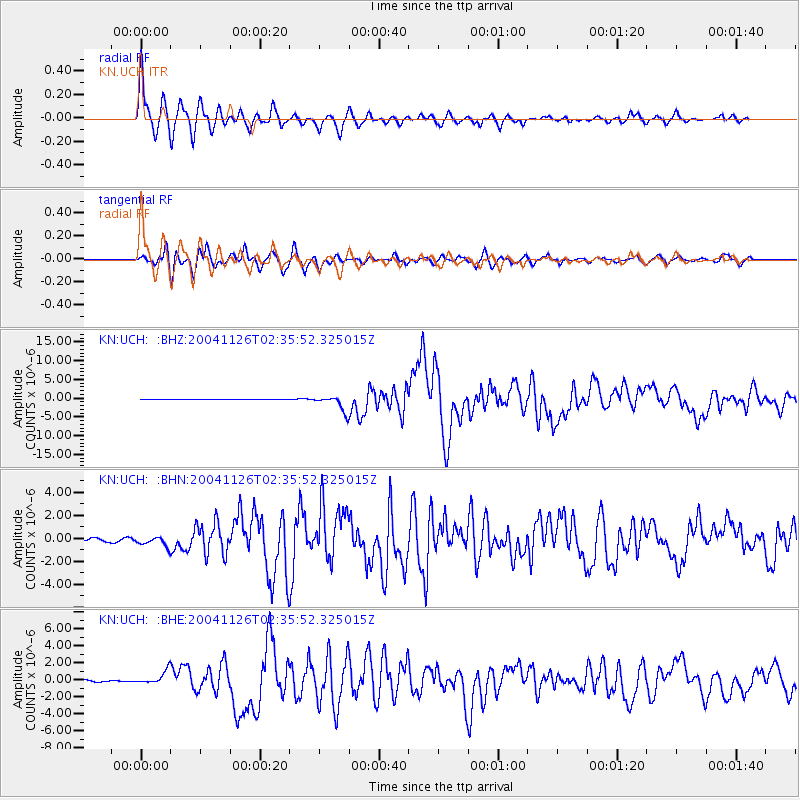
Earthquake location: Irian Jaya Region, Indonesia
Earthquake latitude/longitude: -3.6/135.4
Earthquake time(UTC): 2004/11/26 (331) 02:25:03 GMT
Earthquake Depth: 10 km
Earthquake Magnitude: 6.2 MB, 7.2 MS, 7.1 MW, 7.0 MW
Earthquake Catalog/Contributor: WHDF/NEIC
Network: KN Kyrgyz Seismic Telemetry Network
Station: UCH KN.UCH
Lat/Lon: 42.23 N/74.51 E
Elevation: 3850 m
Distance: 71.4 deg
Az: 316.794 deg
Baz: 113.079 deg
Ray Param: 0.054345
Estimated Moho Depth: 10.0 km
Estimated Crust Vp/Vs: 1.70
Assumed Crust Vp: 6.306 km/s
Estimated Crust Vs: 3.709 km/s
Estimated Crust Poisson's Ratio: 0.24
Radial Match: 95.67168 %
Radial Bump: 340
Transverse Match: 86.008766 %
Transverse Bump: 400
SOD ConfigId: 2459
Insert Time: 2010-03-08 21:25:45.786 +0000
GWidth: 2.5
Max Bumps: 400
Tol: 0.001

Signal To Noise

ChannelStoNSTALTA
KN:UCH: :BHN:20041126T02:35:52.325015Z3.7361754.2813082E-71.1459068E-7
KN:UCH: :BHE:20041126T02:35:52.325015Z5.9077717.6428285E-71.2936907E-7
KN:UCH: :BHZ:20041126T02:35:52.325015Z31.1656952.1054216E-66.755574E-8
Arrivals
Ps1.2 SECOND
PpPs4.1 SECOND
PsPs/PpSs5.3 SECOND