You are here: Home > Network List > TA - USArray Transportable Network (new EarthScope stations) Stations List
> Station F15K North Star Ditch, AK, USA > Earthquake Result Viewer
F15K North Star Ditch, AK, USA - Earthquake Result Viewer
| Earthquake location: |
Turkey |
| Earthquake latitude/longitude: |
39.4/40.7 |
| Earthquake time(UTC): |
2020/06/14 (166) 14:24:29 GMT |
| Earthquake Depth: |
10 km |
| Earthquake Magnitude: |
5.9 Mww |
| Earthquake Catalog/Contributor: |
NEIC PDE/us |
|
| Network: |
TA USArray Transportable Network (new EarthScope stations) |
| Station: |
F15K North Star Ditch, AK, USA |
| Lat/Lon: |
65.71 N/164.65 W |
| Elevation: |
388 m |
|
| Distance: |
73.4 deg |
| Az: |
10.653 deg |
| Baz: |
339.735 deg |
| Ray Param: |
0.053024966 |
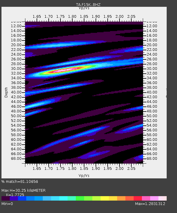
| Estimated Moho Depth: |
30.25 km |
| Estimated Crust Vp/Vs: |
1.77 |
| Assumed Crust Vp: |
6.276 km/s |
| Estimated Crust Vs: |
3.541 km/s |
| Estimated Crust Poisson's Ratio: |
0.27 |
|
| Radial Match: |
81.10656 % |
| Radial Bump: |
400 |
| Transverse Match: |
57.65643 % |
| Transverse Bump: |
400 |
| SOD ConfigId: |
21709731 |
| Insert Time: |
2020-06-28 14:37:59.675 +0000 |
| GWidth: |
2.5 |
| Max Bumps: |
400 |
| Tol: |
0.001 |
|

Signal To Noise
| Channel | StoN | STA | LTA |
| TA:F15K: :BHZ:20200614T14:35:30.375006Z | 3.0848396 | 1.4451251E-7 | 4.6846036E-8 |
| TA:F15K: :BHN:20200614T14:35:30.375006Z | 1.1650312 | 4.217413E-8 | 3.62E-8 |
| TA:F15K: :BHE:20200614T14:35:30.375006Z | 1.1838357 | 3.8068062E-8 | 3.2156542E-8 |
| Arrivals |
| Ps | 3.8 SECOND |
| PpPs | 13 SECOND |
| PsPs/PpSs | 17 SECOND |


