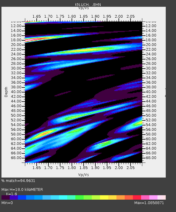
UCH KN.UCH - Earthquake Result Viewer
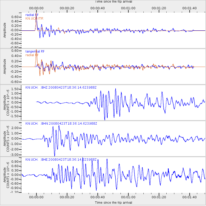
Earthquake location: Taiwan Region
Earthquake latitude/longitude: 22.9/121.6
Earthquake time(UTC): 2008/04/23 (114) 18:28:41 GMT
Earthquake Depth: 10 km
Earthquake Magnitude: 5.6 MB, 5.9 MS, 6.0 MW, 6.0 MW
Earthquake Catalog/Contributor: WHDF/NEIC
Network: KN Kyrgyz Seismic Telemetry Network
Station: UCH KN.UCH
Lat/Lon: 42.23 N/74.51 E
Elevation: 3850 m
Distance: 43.5 deg
Az: 307.802 deg
Baz: 101.151 deg
Ray Param: 0.07249785
Estimated Moho Depth: 18.0 km
Estimated Crust Vp/Vs: 1.60
Assumed Crust Vp: 6.306 km/s
Estimated Crust Vs: 3.941 km/s
Estimated Crust Poisson's Ratio: 0.18
Radial Match: 94.9631 %
Radial Bump: 400
Transverse Match: 89.48989 %
Transverse Bump: 400
SOD ConfigId: 2504
Insert Time: 2010-03-08 21:26:04.869 +0000
GWidth: 2.5
Max Bumps: 400
Tol: 0.001

Signal To Noise

ChannelStoNSTALTA
KN:UCH: :BHN:20080423T18:36:14.623988Z1.86784151.8682897E-71.00024E-7
KN:UCH: :BHE:20080423T18:36:14.623988Z0.88513935.0455238E-85.7002598E-8
KN:UCH: :BHZ:20080423T18:36:14.623988Z2.23329621.3308646E-75.959194E-8
Arrivals
Ps1.8 SECOND
PpPs6.9 SECOND
PsPs/PpSs8.8 SECOND