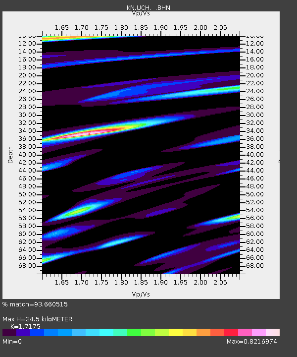
UCH KN.UCH - Earthquake Result Viewer
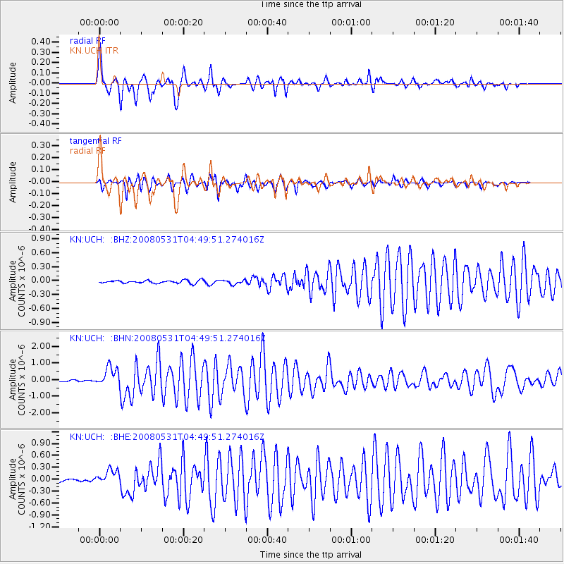
Earthquake location: Mid-Indian Ridge
Earthquake latitude/longitude: -41.2/80.5
Earthquake time(UTC): 2008/05/31 (152) 04:37:56 GMT
Earthquake Depth: 10 km
Earthquake Magnitude: 6.0 MB, 6.3 MS, 6.4 MW, 6.4 MW
Earthquake Catalog/Contributor: WHDF/NEIC
Network: KN Kyrgyz Seismic Telemetry Network
Station: UCH KN.UCH
Lat/Lon: 42.23 N/74.51 E
Elevation: 3850 m
Distance: 83.2 deg
Az: 355.519 deg
Baz: 175.449 deg
Ray Param: 0.046331502
Estimated Moho Depth: 34.5 km
Estimated Crust Vp/Vs: 1.72
Assumed Crust Vp: 6.306 km/s
Estimated Crust Vs: 3.672 km/s
Estimated Crust Poisson's Ratio: 0.24
Radial Match: 93.660515 %
Radial Bump: 400
Transverse Match: 94.81716 %
Transverse Bump: 400
SOD ConfigId: 2504
Insert Time: 2010-03-08 21:26:22.261 +0000
GWidth: 2.5
Max Bumps: 400
Tol: 0.001

Signal To Noise

ChannelStoNSTALTA
KN:UCH: :BHN:20080531T04:49:51.274016Z11.41363055.9512155E-75.21413E-8
KN:UCH: :BHE:20080531T04:49:51.274016Z4.7882151.8979023E-73.9636944E-8
KN:UCH: :BHZ:20080531T04:49:51.274016Z1.4293614.3774968E-83.062555E-8
Arrivals
Ps4.0 SECOND
PpPs14 SECOND
PsPs/PpSs19 SECOND