You are here: Home > Network List > KN - Kyrgyz Seismic Telemetry Network Stations List
> Station UCH KN.UCH > Earthquake Result Viewer
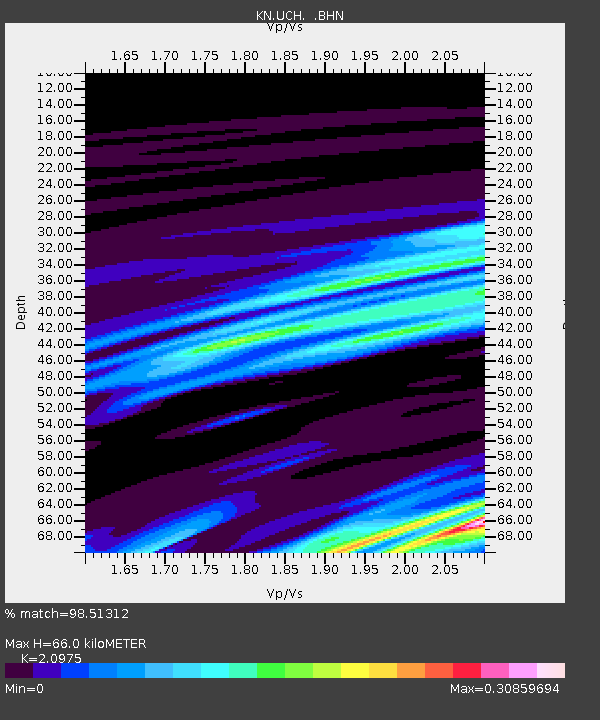
UCH KN.UCH - Earthquake Result Viewer
| Earthquake location: |
Sunda Strait, Indonesia |
| Earthquake latitude/longitude: |
-6.3/104.5 |
| Earthquake time(UTC): |
2008/08/26 (239) 03:07:29 GMT |
| Earthquake Depth: |
22 km |
| Earthquake Magnitude: |
5.7 MB, 5.4 MS, 5.7 MW, 5.7 MW |
| Earthquake Catalog/Contributor: |
WHDF/NEIC |
|
| Network: |
KN Kyrgyz Seismic Telemetry Network |
| Station: |
UCH KN.UCH |
| Lat/Lon: |
42.23 N/74.51 E |
| Elevation: |
3850 m |
|
| Distance: |
55.5 deg |
| Az: |
333.261 deg |
| Baz: |
142.978 deg |
| Ray Param: |
0.06471472 |
| Estimated Moho Depth: |
66.0 km |
| Estimated Crust Vp/Vs: |
2.10 |
| Assumed Crust Vp: |
6.306 km/s |
| Estimated Crust Vs: |
3.006 km/s |
| Estimated Crust Poisson's Ratio: |
0.35 |
|
| Radial Match: |
98.51312 % |
| Radial Bump: |
211 |
| Transverse Match: |
99.00704 % |
| Transverse Bump: |
96 |
| SOD ConfigId: |
2504 |
| Insert Time: |
2010-03-08 21:26:41.875 +0000 |
| GWidth: |
2.5 |
| Max Bumps: |
400 |
| Tol: |
0.001 |
|

Signal To Noise
| Channel | StoN | STA | LTA |
| KN:UCH: :BHN:20080826T03:16:31.900024Z | 3.6900613 | 1.2093588E-7 | 3.2773404E-8 |
| KN:UCH: :BHE:20080826T03:16:31.900024Z | 1.1354182 | 1.2071912E-7 | 1.0632129E-7 |
| KN:UCH: :BHZ:20080826T03:16:31.900024Z | 4.076141 | 1.7023656E-7 | 4.176415E-8 |
| Arrivals |
| Ps | 12 SECOND |
| PpPs | 31 SECOND |
| PsPs/PpSs | 43 SECOND |


