You are here: Home > Network List > US - United States National Seismic Network Stations List
> Station DGMT Dagmar, Montana, USA > Earthquake Result Viewer
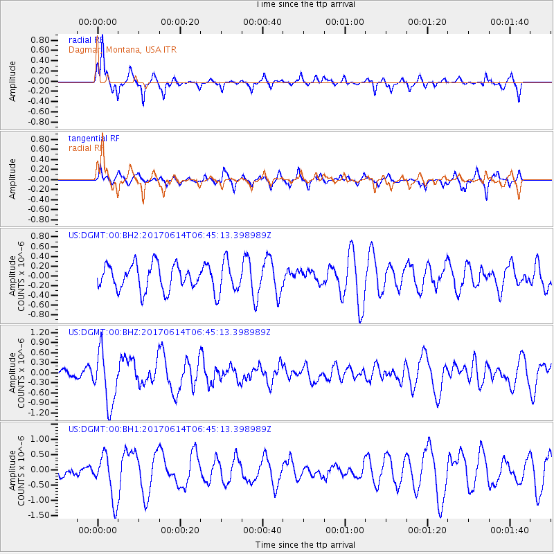
DGMT Dagmar, Montana, USA - Earthquake Result Viewer
*The percent match for this event was below the threshold and hence no stack was calculated.
| Earthquake location: |
Near Coast Of Chiapas, Mexico |
| Earthquake latitude/longitude: |
14.2/-93.2 |
| Earthquake time(UTC): |
2017/06/14 (165) 06:38:48 GMT |
| Earthquake Depth: |
11 km |
| Earthquake Magnitude: |
5.5 Mww |
| Earthquake Catalog/Contributor: |
NEIC PDE/us |
|
| Network: |
US United States National Seismic Network |
| Station: |
DGMT Dagmar, Montana, USA |
| Lat/Lon: |
48.47 N/104.20 W |
| Elevation: |
0.0 m |
|
| Distance: |
35.3 deg |
| Az: |
347.269 deg |
| Baz: |
161.27 deg |
| Ray Param: |
$rayparam |
*The percent match for this event was below the threshold and hence was not used in the summary stack. |
|
| Radial Match: |
78.44197 % |
| Radial Bump: |
275 |
| Transverse Match: |
65.421745 % |
| Transverse Bump: |
343 |
| SOD ConfigId: |
2140511 |
| Insert Time: |
2017-06-27 22:32:51.440 +0000 |
| GWidth: |
2.5 |
| Max Bumps: |
400 |
| Tol: |
0.001 |
|
Signal To Noise
| Channel | StoN | STA | LTA |
| US:DGMT:00:BHZ:20170614T06:45:13.398989Z | 8.996687 | 8.1469557E-7 | 9.055506E-8 |
| US:DGMT:00:BH1:20170614T06:45:13.398989Z | 1.9050869 | 7.663452E-7 | 4.022626E-7 |
| US:DGMT:00:BH2:20170614T06:45:13.398989Z | 1.2825745 | 3.2662416E-7 | 2.546629E-7 |
| Arrivals |
| Ps | |
| PpPs | |
| PsPs/PpSs | |


