You are here: Home > Network List > KN - Kyrgyz Seismic Telemetry Network Stations List
> Station UCH KN.UCH > Earthquake Result Viewer
UCH KN.UCH - Earthquake Result Viewer
| Earthquake location: |
Philippine Islands Region |
| Earthquake latitude/longitude: |
19.9/121.3 |
| Earthquake time(UTC): |
2008/03/03 (063) 13:49:40 GMT |
| Earthquake Depth: |
10 km |
| Earthquake Magnitude: |
6.0 MB, 6.0 MW, 5.9 MW |
| Earthquake Catalog/Contributor: |
WHDF/NEIC |
|
| Network: |
KN Kyrgyz Seismic Telemetry Network |
| Station: |
UCH KN.UCH |
| Lat/Lon: |
42.23 N/74.51 E |
| Elevation: |
3850 m |
|
| Distance: |
45.2 deg |
| Az: |
310.218 deg |
| Baz: |
104.673 deg |
| Ray Param: |
0.071450844 |
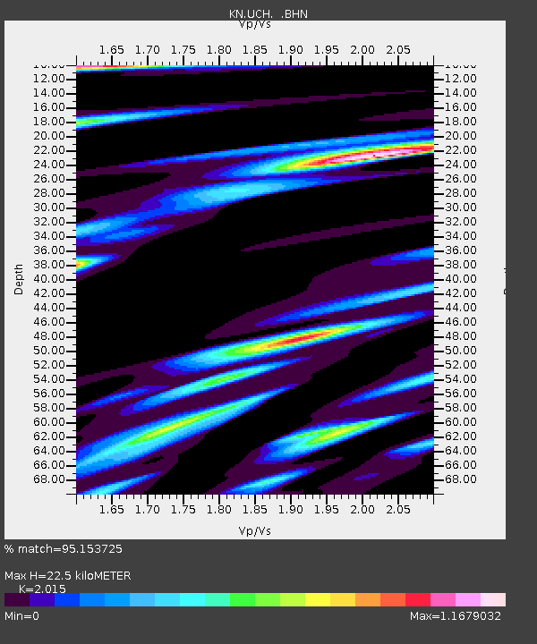
| Estimated Moho Depth: |
22.5 km |
| Estimated Crust Vp/Vs: |
2.02 |
| Assumed Crust Vp: |
6.306 km/s |
| Estimated Crust Vs: |
3.13 km/s |
| Estimated Crust Poisson's Ratio: |
0.34 |
|
| Radial Match: |
95.153725 % |
| Radial Bump: |
400 |
| Transverse Match: |
88.20697 % |
| Transverse Bump: |
400 |
| SOD ConfigId: |
2564 |
| Insert Time: |
2010-03-08 21:26:57.849 +0000 |
| GWidth: |
2.5 |
| Max Bumps: |
400 |
| Tol: |
0.001 |
|
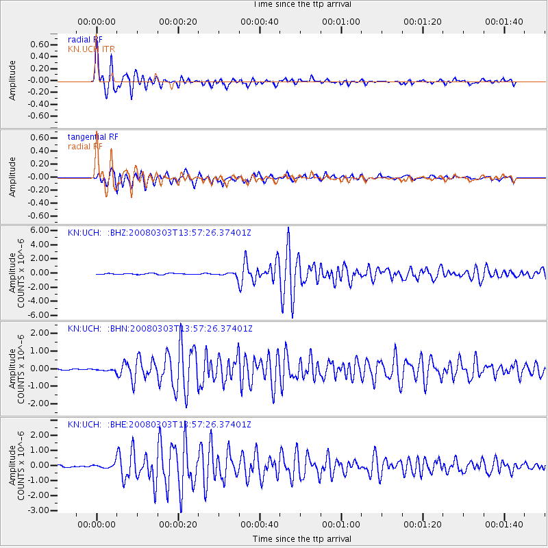
Signal To Noise
| Channel | StoN | STA | LTA |
| KN:UCH: :BHN:20080303T13:57:26.37401Z | 0.698744 | 4.613243E-8 | 6.602193E-8 |
| KN:UCH: :BHE:20080303T13:57:26.37401Z | 2.5242627 | 1.6467561E-7 | 6.523712E-8 |
| KN:UCH: :BHZ:20080303T13:57:26.37401Z | 4.5452456 | 3.4082743E-7 | 7.498548E-8 |
| Arrivals |
| Ps | 3.8 SECOND |
| PpPs | 10 SECOND |
| PsPs/PpSs | 14 SECOND |


