You are here: Home > Network List > TA - USArray Transportable Network (new EarthScope stations) Stations List
> Station C19K Lookout Ridge, AK, USA > Earthquake Result Viewer
C19K Lookout Ridge, AK, USA - Earthquake Result Viewer
| Earthquake location: |
Halmahera, Indonesia |
| Earthquake latitude/longitude: |
1.3/128.1 |
| Earthquake time(UTC): |
2020/06/15 (167) 04:15:43 GMT |
| Earthquake Depth: |
116 km |
| Earthquake Magnitude: |
5.2 Mww |
| Earthquake Catalog/Contributor: |
NEIC PDE/us |
|
| Network: |
TA USArray Transportable Network (new EarthScope stations) |
| Station: |
C19K Lookout Ridge, AK, USA |
| Lat/Lon: |
69.10 N/159.59 W |
| Elevation: |
745 m |
|
| Distance: |
82.5 deg |
| Az: |
20.168 deg |
| Baz: |
253.905 deg |
| Ray Param: |
0.046568427 |
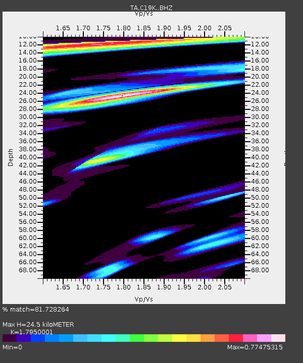
| Estimated Moho Depth: |
24.5 km |
| Estimated Crust Vp/Vs: |
1.80 |
| Assumed Crust Vp: |
6.221 km/s |
| Estimated Crust Vs: |
3.466 km/s |
| Estimated Crust Poisson's Ratio: |
0.27 |
|
| Radial Match: |
81.728264 % |
| Radial Bump: |
400 |
| Transverse Match: |
77.7608 % |
| Transverse Bump: |
400 |
| SOD ConfigId: |
21709731 |
| Insert Time: |
2020-06-29 04:25:02.004 +0000 |
| GWidth: |
2.5 |
| Max Bumps: |
400 |
| Tol: |
0.001 |
|

Signal To Noise
| Channel | StoN | STA | LTA |
| TA:C19K: :BHZ:20200615T04:27:22.42501Z | 11.252271 | 8.244006E-7 | 7.326527E-8 |
| TA:C19K: :BHN:20200615T04:27:22.42501Z | 4.535502 | 2.0489615E-7 | 4.517607E-8 |
| TA:C19K: :BHE:20200615T04:27:22.42501Z | 4.5643167 | 1.8299302E-7 | 4.0092093E-8 |
| Arrivals |
| Ps | 3.2 SECOND |
| PpPs | 11 SECOND |
| PsPs/PpSs | 14 SECOND |


