You are here: Home > Network List > KN - Kyrgyz Seismic Telemetry Network Stations List
> Station UCH KN.UCH > Earthquake Result Viewer
UCH KN.UCH - Earthquake Result Viewer
| Earthquake location: |
Kuril Islands |
| Earthquake latitude/longitude: |
44.6/149.4 |
| Earthquake time(UTC): |
1995/12/03 (337) 18:01:08 GMT |
| Earthquake Depth: |
33 km |
| Earthquake Magnitude: |
6.6 MB, 8.0 MS |
| Earthquake Catalog/Contributor: |
WHDF/NEIC |
|
| Network: |
KN Kyrgyz Seismic Telemetry Network |
| Station: |
UCH KN.UCH |
| Lat/Lon: |
42.23 N/74.51 E |
| Elevation: |
3850 m |
|
| Distance: |
52.6 deg |
| Az: |
295.565 deg |
| Baz: |
60.244 deg |
| Ray Param: |
0.06657475 |
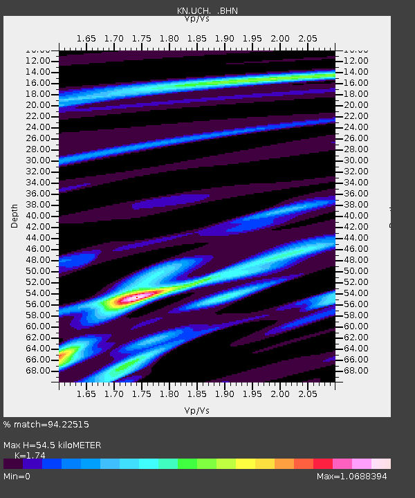
| Estimated Moho Depth: |
54.5 km |
| Estimated Crust Vp/Vs: |
1.74 |
| Assumed Crust Vp: |
6.306 km/s |
| Estimated Crust Vs: |
3.624 km/s |
| Estimated Crust Poisson's Ratio: |
0.25 |
|
| Radial Match: |
94.22515 % |
| Radial Bump: |
384 |
| Transverse Match: |
82.207634 % |
| Transverse Bump: |
400 |
| SOD ConfigId: |
6273 |
| Insert Time: |
2010-03-08 21:27:17.182 +0000 |
| GWidth: |
2.5 |
| Max Bumps: |
400 |
| Tol: |
0.001 |
|

Signal To Noise
| Channel | StoN | STA | LTA |
| KN:UCH: :BHN:19951203T18:09:48.674011Z | 3.5473554 | 3.4949844E-7 | 9.852366E-8 |
| KN:UCH: :BHE:19951203T18:09:48.674011Z | 4.805698 | 4.6418887E-7 | 9.659136E-8 |
| KN:UCH: :BHZ:19951203T18:09:48.674011Z | 5.2106028 | 1.0614316E-6 | 2.037061E-7 |
| Arrivals |
| Ps | 6.7 SECOND |
| PpPs | 22 SECOND |
| PsPs/PpSs | 29 SECOND |


