You are here: Home > Network List > AK - Alaska Regional Network Stations List
> Station PS10 TAPS Pump Station 10, AK, USA > Earthquake Result Viewer
PS10 TAPS Pump Station 10, AK, USA - Earthquake Result Viewer
| Earthquake location: |
Tajikistan |
| Earthquake latitude/longitude: |
37.8/72.2 |
| Earthquake time(UTC): |
2020/06/16 (168) 01:30:48 GMT |
| Earthquake Depth: |
127 km |
| Earthquake Magnitude: |
5.6 mww |
| Earthquake Catalog/Contributor: |
NEIC PDE/us |
|
| Network: |
AK Alaska Regional Network |
| Station: |
PS10 TAPS Pump Station 10, AK, USA |
| Lat/Lon: |
63.42 N/145.77 W |
| Elevation: |
738 m |
|
| Distance: |
74.6 deg |
| Az: |
16.68 deg |
| Baz: |
329.654 deg |
| Ray Param: |
0.051887847 |
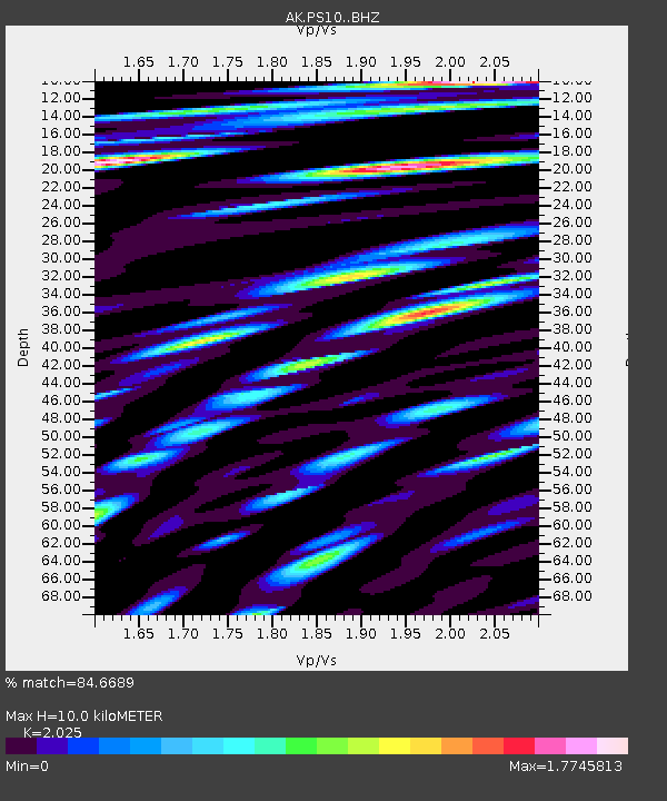
| Estimated Moho Depth: |
10.0 km |
| Estimated Crust Vp/Vs: |
2.03 |
| Assumed Crust Vp: |
6.566 km/s |
| Estimated Crust Vs: |
3.243 km/s |
| Estimated Crust Poisson's Ratio: |
0.34 |
|
| Radial Match: |
84.6689 % |
| Radial Bump: |
400 |
| Transverse Match: |
85.73316 % |
| Transverse Bump: |
400 |
| SOD ConfigId: |
21709731 |
| Insert Time: |
2020-06-30 01:33:59.058 +0000 |
| GWidth: |
2.5 |
| Max Bumps: |
400 |
| Tol: |
0.001 |
|

Signal To Noise
| Channel | StoN | STA | LTA |
| AK:PS10: :BHZ:20200616T01:41:42.848027Z | 3.98171 | 5.688858E-7 | 1.4287475E-7 |
| AK:PS10: :BHN:20200616T01:41:42.848027Z | 4.6721616 | 5.8429555E-7 | 1.2505893E-7 |
| AK:PS10: :BHE:20200616T01:41:42.848027Z | 7.8093553 | 7.9548755E-7 | 1.01863414E-7 |
| Arrivals |
| Ps | 1.6 SECOND |
| PpPs | 4.5 SECOND |
| PsPs/PpSs | 6.1 SECOND |


