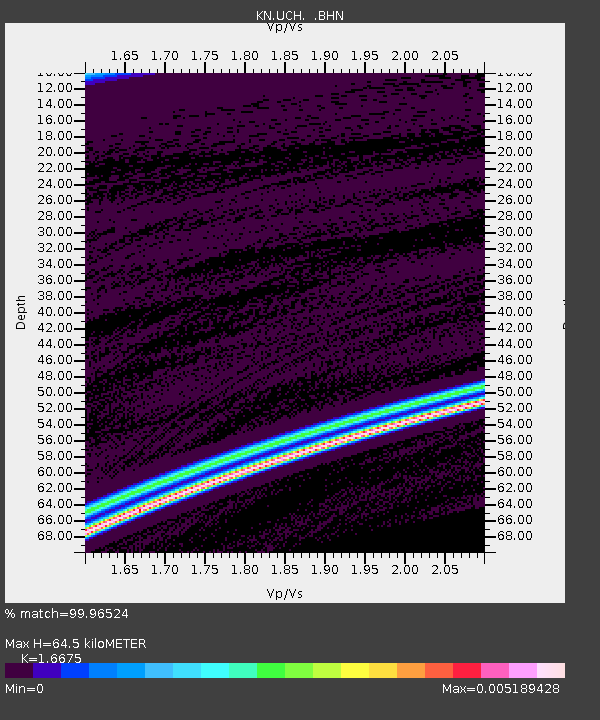
UCH KN.UCH - Earthquake Result Viewer
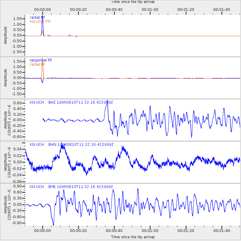
Earthquake location: New Britain Region, P.N.G.
Earthquake latitude/longitude: -4.9/152.1
Earthquake time(UTC): 1996/08/10 (223) 11:20:19 GMT
Earthquake Depth: 33 km
Earthquake Magnitude: 5.6 MB, 6.0 MS, 6.2 UNKNOWN, 6.1 MW
Earthquake Catalog/Contributor: WHDF/NEIC
Network: KN Kyrgyz Seismic Telemetry Network
Station: UCH KN.UCH
Lat/Lon: 42.23 N/74.51 E
Elevation: 3850 m
Distance: 84.2 deg
Az: 313.18 deg
Baz: 101.984 deg
Ray Param: 0.045623284
Estimated Moho Depth: 64.5 km
Estimated Crust Vp/Vs: 1.67
Assumed Crust Vp: 6.306 km/s
Estimated Crust Vs: 3.782 km/s
Estimated Crust Poisson's Ratio: 0.22
Radial Match: 99.96524 %
Radial Bump: 3
Transverse Match: 95.77 %
Transverse Bump: 194
SOD ConfigId: 6273
Insert Time: 2010-03-08 21:28:06.153 +0000
GWidth: 2.5
Max Bumps: 400
Tol: 0.001

Signal To Noise

ChannelStoNSTALTA
KN:UCH: :BHN:19960810T11:32:16.423999Z1.18790561.8000962E-81.515353E-8
KN:UCH: :BHE:19960810T11:32:16.423999Z2.71653961.0201881E-73.7554692E-8
KN:UCH: :BHZ:19960810T11:32:16.423999Z2.70397.4215976E-82.7447749E-8
Arrivals
Ps7.0 SECOND
PpPs27 SECOND
PsPs/PpSs34 SECOND