You are here: Home > Network List > G - GEOSCOPE Stations List
> Station TAOE Taiohae, Marquises islands > Earthquake Result Viewer
TAOE Taiohae, Marquises islands - Earthquake Result Viewer
| Earthquake location: |
Near Coast Of Chiapas, Mexico |
| Earthquake latitude/longitude: |
14.9/-92.0 |
| Earthquake time(UTC): |
2017/06/14 (165) 07:29:03 GMT |
| Earthquake Depth: |
98 km |
| Earthquake Magnitude: |
7.0 Mi |
| Earthquake Catalog/Contributor: |
NEIC PDE/at |
|
| Network: |
G GEOSCOPE |
| Station: |
TAOE Taiohae, Marquises islands |
| Lat/Lon: |
8.85 S/140.15 W |
| Elevation: |
800 m |
|
| Distance: |
53.2 deg |
| Az: |
246.745 deg |
| Baz: |
64.004 deg |
| Ray Param: |
0.065917574 |
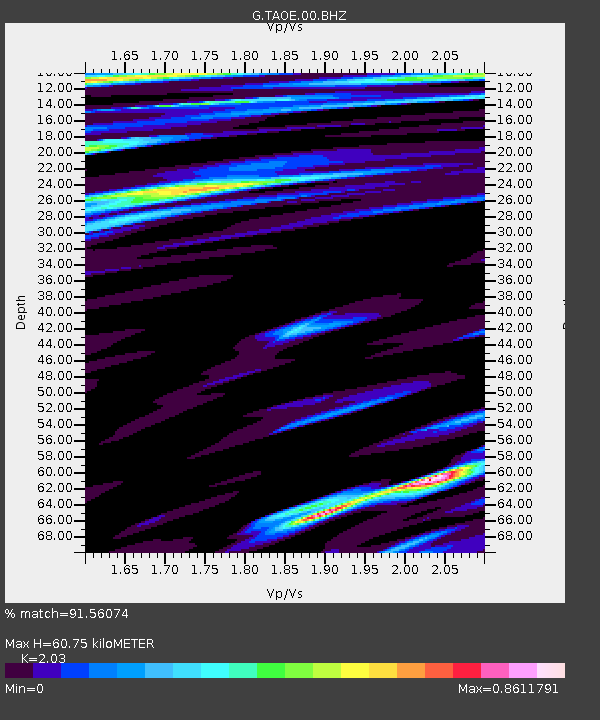
| Estimated Moho Depth: |
60.75 km |
| Estimated Crust Vp/Vs: |
2.03 |
| Assumed Crust Vp: |
4.24 km/s |
| Estimated Crust Vs: |
2.089 km/s |
| Estimated Crust Poisson's Ratio: |
0.34 |
|
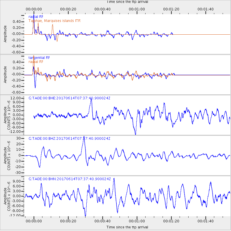
| Radial Match: |
91.56074 % |
| Radial Bump: |
336 |
| Transverse Match: |
87.81782 % |
| Transverse Bump: |
400 |
| SOD ConfigId: |
2140511 |
| Insert Time: |
2017-06-27 23:21:38.698 +0000 |
| GWidth: |
2.5 |
| Max Bumps: |
400 |
| Tol: |
0.001 |
|
Signal To Noise
| Channel | StoN | STA | LTA |
| G:TAOE:00:BHZ:20170614T07:37:40.900024Z | 9.189015 | 8.780752E-6 | 9.555705E-7 |
| G:TAOE:00:BHN:20170614T07:37:40.900024Z | 3.2417924 | 2.9445107E-6 | 9.082971E-7 |
| G:TAOE:00:BHE:20170614T07:37:40.900024Z | 5.889666 | 5.0566655E-6 | 8.585657E-7 |
| Arrivals |
| Ps | 15 SECOND |
| PpPs | 43 SECOND |
| PsPs/PpSs | 58 SECOND |


