You are here: Home > Network List > KN - Kyrgyz Seismic Telemetry Network Stations List
> Station UCH KN.UCH > Earthquake Result Viewer
UCH KN.UCH - Earthquake Result Viewer

| Earthquake location: |
Luzon, Philippines |
| Earthquake latitude/longitude: |
18.3/121.0 |
| Earthquake time(UTC): |
1997/04/08 (098) 18:07:09 GMT |
| Earthquake Depth: |
71 km |
| Earthquake Magnitude: |
6.0 MB, 5.9 UNKNOWN, 5.9 MW |
| Earthquake Catalog/Contributor: |
WHDF/NEIC |
|
| Network: |
KN Kyrgyz Seismic Telemetry Network |
| Station: |
UCH KN.UCH |
| Lat/Lon: |
42.23 N/74.51 E |
| Elevation: |
3850 m |
|
| Distance: |
45.9 deg |
| Az: |
311.504 deg |
| Baz: |
106.687 deg |
| Ray Param: |
0.070739806 |
| Estimated Moho Depth: |
10.0 km |
| Estimated Crust Vp/Vs: |
1.63 |
| Assumed Crust Vp: |
6.306 km/s |
| Estimated Crust Vs: |
3.863 km/s |
| Estimated Crust Poisson's Ratio: |
0.20 |
|
| Radial Match: |
94.10974 % |
| Radial Bump: |
400 |
| Transverse Match: |
93.51699 % |
| Transverse Bump: |
400 |
| SOD ConfigId: |
6273 |
| Insert Time: |
2010-03-08 21:29:04.881 +0000 |
| GWidth: |
2.5 |
| Max Bumps: |
400 |
| Tol: |
0.001 |
|
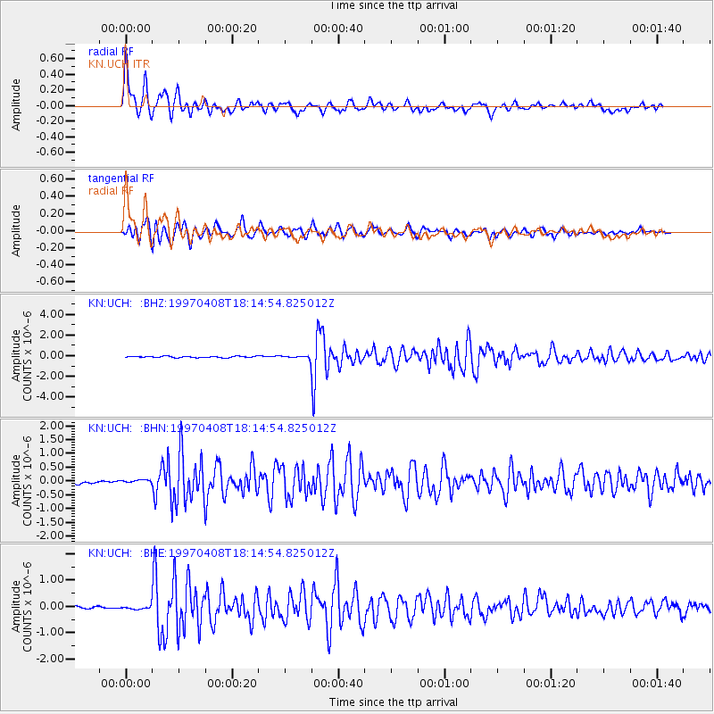
Signal To Noise
| Channel | StoN | STA | LTA |
| KN:UCH: :BHN:19970408T18:14:54.825012Z | 1.390316 | 5.8340394E-8 | 4.1961968E-8 |
| KN:UCH: :BHE:19970408T18:14:54.825012Z | 1.5858996 | 5.8208794E-8 | 3.670396E-8 |
| KN:UCH: :BHZ:19970408T18:14:54.825012Z | 2.3748174 | 1.3937462E-7 | 5.8688563E-8 |
| Arrivals |
| Ps | 1.1 SECOND |
| PpPs | 3.9 SECOND |
| PsPs/PpSs | 5.0 SECOND |


