You are here: Home > Network List > TA - USArray Transportable Network (new EarthScope stations) Stations List
> Station H16K Elim, AK, USA > Earthquake Result Viewer
H16K Elim, AK, USA - Earthquake Result Viewer
| Earthquake location: |
Tajikistan |
| Earthquake latitude/longitude: |
37.8/72.2 |
| Earthquake time(UTC): |
2020/06/16 (168) 01:30:48 GMT |
| Earthquake Depth: |
127 km |
| Earthquake Magnitude: |
5.6 mww |
| Earthquake Catalog/Contributor: |
NEIC PDE/us |
|
| Network: |
TA USArray Transportable Network (new EarthScope stations) |
| Station: |
H16K Elim, AK, USA |
| Lat/Lon: |
64.64 N/162.24 W |
| Elevation: |
216 m |
|
| Distance: |
69.3 deg |
| Az: |
21.993 deg |
| Baz: |
316.491 deg |
| Ray Param: |
0.055381387 |
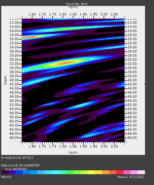
| Estimated Moho Depth: |
19.25 km |
| Estimated Crust Vp/Vs: |
1.60 |
| Assumed Crust Vp: |
6.276 km/s |
| Estimated Crust Vs: |
3.916 km/s |
| Estimated Crust Poisson's Ratio: |
0.18 |
|
| Radial Match: |
81.67412 % |
| Radial Bump: |
400 |
| Transverse Match: |
61.3929 % |
| Transverse Bump: |
400 |
| SOD ConfigId: |
21709731 |
| Insert Time: |
2020-06-30 01:45:50.927 +0000 |
| GWidth: |
2.5 |
| Max Bumps: |
400 |
| Tol: |
0.001 |
|

Signal To Noise
| Channel | StoN | STA | LTA |
| TA:H16K: :BHZ:20200616T01:41:11.275029Z | 3.0555084 | 1.8328564E-7 | 5.998531E-8 |
| TA:H16K: :BHN:20200616T01:41:11.275029Z | 2.7991621 | 8.379746E-8 | 2.9936622E-8 |
| TA:H16K: :BHE:20200616T01:41:11.275029Z | 1.5556931 | 6.094085E-8 | 3.9172797E-8 |
| Arrivals |
| Ps | 1.9 SECOND |
| PpPs | 7.7 SECOND |
| PsPs/PpSs | 9.6 SECOND |


