You are here: Home > Network List > TA - USArray Transportable Network (new EarthScope stations) Stations List
> Station I30M Mount Dempster, Yukon, CAN > Earthquake Result Viewer
I30M Mount Dempster, Yukon, CAN - Earthquake Result Viewer
| Earthquake location: |
Tajikistan |
| Earthquake latitude/longitude: |
37.8/72.2 |
| Earthquake time(UTC): |
2020/06/16 (168) 01:30:48 GMT |
| Earthquake Depth: |
127 km |
| Earthquake Magnitude: |
5.6 mww |
| Earthquake Catalog/Contributor: |
NEIC PDE/us |
|
| Network: |
TA USArray Transportable Network (new EarthScope stations) |
| Station: |
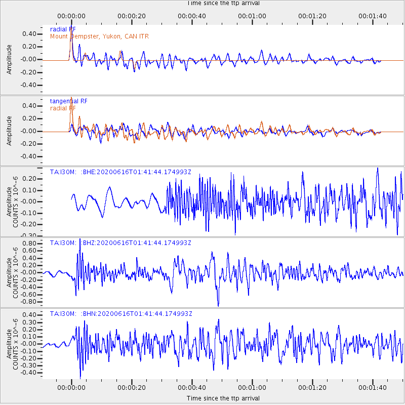
I30M Mount Dempster, Yukon, CAN |
| Lat/Lon: |
65.22 N/136.38 W |
| Elevation: |
1399 m |
|
| Distance: |
74.9 deg |
| Az: |
12.056 deg |
| Baz: |
336.896 deg |
| Ray Param: |
0.05173894 |
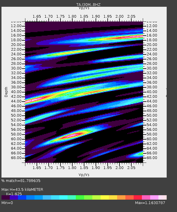
| Estimated Moho Depth: |
43.5 km |
| Estimated Crust Vp/Vs: |
1.62 |
| Assumed Crust Vp: |
6.566 km/s |
| Estimated Crust Vs: |
4.041 km/s |
| Estimated Crust Poisson's Ratio: |
0.20 |
|
| Radial Match: |
81.789635 % |
| Radial Bump: |
400 |
| Transverse Match: |
71.674736 % |
| Transverse Bump: |
400 |
| SOD ConfigId: |
21709731 |
| Insert Time: |
2020-06-30 01:46:07.205 +0000 |
| GWidth: |
2.5 |
| Max Bumps: |
400 |
| Tol: |
0.001 |
|
Signal To Noise
| Channel | StoN | STA | LTA |
| TA:I30M: :BHZ:20200616T01:41:44.174993Z | 4.1983576 | 3.3276922E-7 | 7.926177E-8 |
| TA:I30M: :BHN:20200616T01:41:44.174993Z | 5.203557 | 1.8126727E-7 | 3.483526E-8 |
| TA:I30M: :BHE:20200616T01:41:44.174993Z | 1.6910512 | 8.769467E-8 | 5.185808E-8 |
| Arrivals |
| Ps | 4.3 SECOND |
| PpPs | 17 SECOND |
| PsPs/PpSs | 21 SECOND |


