You are here: Home > Network List > TA - USArray Transportable Network (new EarthScope stations) Stations List
> Station K13K Kusilvak Mountain, AK, USA > Earthquake Result Viewer
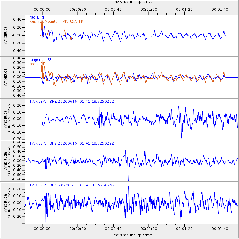
K13K Kusilvak Mountain, AK, USA - Earthquake Result Viewer
*The percent match for this event was below the threshold and hence no stack was calculated.
| Earthquake location: |
Tajikistan |
| Earthquake latitude/longitude: |
37.8/72.2 |
| Earthquake time(UTC): |
2020/06/16 (168) 01:30:48 GMT |
| Earthquake Depth: |
127 km |
| Earthquake Magnitude: |
5.6 mww |
| Earthquake Catalog/Contributor: |
NEIC PDE/us |
|
| Network: |
TA USArray Transportable Network (new EarthScope stations) |
| Station: |
K13K Kusilvak Mountain, AK, USA |
| Lat/Lon: |
61.93 N/164.66 W |
| Elevation: |
204 m |
|
| Distance: |
70.5 deg |
| Az: |
24.84 deg |
| Baz: |
315.312 deg |
| Ray Param: |
$rayparam |
*The percent match for this event was below the threshold and hence was not used in the summary stack. |
|
| Radial Match: |
65.86217 % |
| Radial Bump: |
400 |
| Transverse Match: |
61.719555 % |
| Transverse Bump: |
400 |
| SOD ConfigId: |
21709731 |
| Insert Time: |
2020-06-30 01:46:14.319 +0000 |
| GWidth: |
2.5 |
| Max Bumps: |
400 |
| Tol: |
0.001 |
|
Signal To Noise
| Channel | StoN | STA | LTA |
| TA:K13K: :BHZ:20200616T01:41:18.525029Z | 2.6612475 | 1.3987874E-7 | 5.2561344E-8 |
| TA:K13K: :BHN:20200616T01:41:18.525029Z | 2.373321 | 9.8999834E-8 | 4.171363E-8 |
| TA:K13K: :BHE:20200616T01:41:18.525029Z | 1.8470901 | 7.39477E-8 | 4.0034703E-8 |
| Arrivals |
| Ps | |
| PpPs | |
| PsPs/PpSs | |


