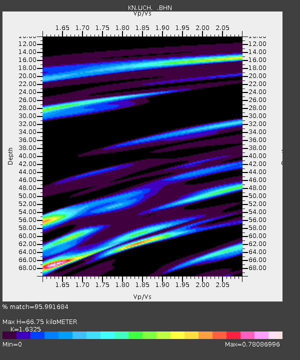
UCH KN.UCH - Earthquake Result Viewer
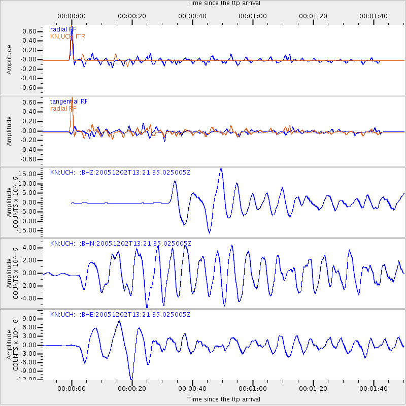
Earthquake location: Near East Coast Of Honshu, Japan
Earthquake latitude/longitude: 38.1/142.1
Earthquake time(UTC): 2005/12/02 (336) 13:13:09 GMT
Earthquake Depth: 29 km
Earthquake Magnitude: 6.1 MB, 6.3 MS, 6.5 MW, 6.4 MW
Earthquake Catalog/Contributor: WHDF/NEIC
Network: KN Kyrgyz Seismic Telemetry Network
Station: UCH KN.UCH
Lat/Lon: 42.23 N/74.51 E
Elevation: 3850 m
Distance: 50.6 deg
Az: 297.307 deg
Baz: 70.734 deg
Ray Param: 0.06788751
Estimated Moho Depth: 66.75 km
Estimated Crust Vp/Vs: 1.63
Assumed Crust Vp: 6.306 km/s
Estimated Crust Vs: 3.863 km/s
Estimated Crust Poisson's Ratio: 0.20
Radial Match: 95.991684 %
Radial Bump: 400
Transverse Match: 93.93908 %
Transverse Bump: 347
SOD ConfigId: 2422
Insert Time: 2010-03-08 21:29:33.389 +0000
GWidth: 2.5
Max Bumps: 400
Tol: 0.001

Signal To Noise

ChannelStoNSTALTA
KN:UCH: :BHN:20051202T13:21:35.025005Z7.8724411.1642311E-61.4788692E-7
KN:UCH: :BHE:20051202T13:21:35.025005Z12.12882.434767E-62.007426E-7
KN:UCH: :BHZ:20051202T13:21:35.025005Z81.439855.101022E-66.263545E-8
Arrivals
Ps7.1 SECOND
PpPs26 SECOND
PsPs/PpSs33 SECOND