You are here: Home > Network List > IU - Global Seismograph Network (GSN - IRIS/USGS) Stations List
> Station PAB San Pablo, Spain > Earthquake Result Viewer
PAB San Pablo, Spain - Earthquake Result Viewer
| Earthquake location: |
Near Coast Of Chiapas, Mexico |
| Earthquake latitude/longitude: |
14.9/-92.0 |
| Earthquake time(UTC): |
2017/06/14 (165) 07:29:03 GMT |
| Earthquake Depth: |
98 km |
| Earthquake Magnitude: |
7.0 Mi |
| Earthquake Catalog/Contributor: |
NEIC PDE/at |
|
| Network: |
IU Global Seismograph Network (GSN - IRIS/USGS) |
| Station: |
PAB San Pablo, Spain |
| Lat/Lon: |
39.54 N/4.35 W |
| Elevation: |
950 m |
|
| Distance: |
78.9 deg |
| Az: |
51.936 deg |
| Baz: |
280.121 deg |
| Ray Param: |
0.049115494 |
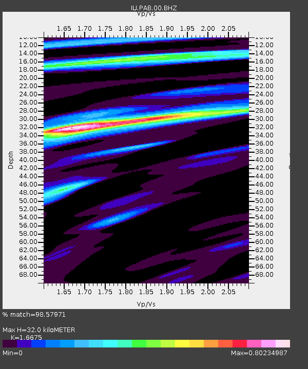
| Estimated Moho Depth: |
32.0 km |
| Estimated Crust Vp/Vs: |
1.67 |
| Assumed Crust Vp: |
6.276 km/s |
| Estimated Crust Vs: |
3.764 km/s |
| Estimated Crust Poisson's Ratio: |
0.22 |
|
| Radial Match: |
98.57971 % |
| Radial Bump: |
368 |
| Transverse Match: |
88.944786 % |
| Transverse Bump: |
400 |
| SOD ConfigId: |
2140511 |
| Insert Time: |
2017-06-27 23:22:32.850 +0000 |
| GWidth: |
2.5 |
| Max Bumps: |
400 |
| Tol: |
0.001 |
|

Signal To Noise
| Channel | StoN | STA | LTA |
| IU:PAB:00:BHZ:20170614T07:40:24.56897Z | 30.145248 | 3.6790482E-6 | 1.2204406E-7 |
| IU:PAB:00:BH1:20170614T07:40:24.56897Z | 4.9456267 | 4.1120978E-7 | 8.314614E-8 |
| IU:PAB:00:BH2:20170614T07:40:24.56897Z | 12.114763 | 1.3466297E-6 | 1.1115609E-7 |
| Arrivals |
| Ps | 3.5 SECOND |
| PpPs | 13 SECOND |
| PsPs/PpSs | 17 SECOND |


