You are here: Home > Network List > KN - Kyrgyz Seismic Telemetry Network Stations List
> Station UCH KN.UCH > Earthquake Result Viewer
UCH KN.UCH - Earthquake Result Viewer
| Earthquake location: |
Mindanao, Philippines |
| Earthquake latitude/longitude: |
5.3/123.3 |
| Earthquake time(UTC): |
2005/02/05 (036) 12:23:18 GMT |
| Earthquake Depth: |
525 km |
| Earthquake Magnitude: |
6.4 MB, 7.1 MW, 7.1 MW |
| Earthquake Catalog/Contributor: |
WHDF/NEIC |
|
| Network: |
KN Kyrgyz Seismic Telemetry Network |
| Station: |
UCH KN.UCH |
| Lat/Lon: |
42.23 N/74.51 E |
| Elevation: |
3850 m |
|
| Distance: |
56.7 deg |
| Az: |
318.05 deg |
| Baz: |
116.331 deg |
| Ray Param: |
0.06181109 |
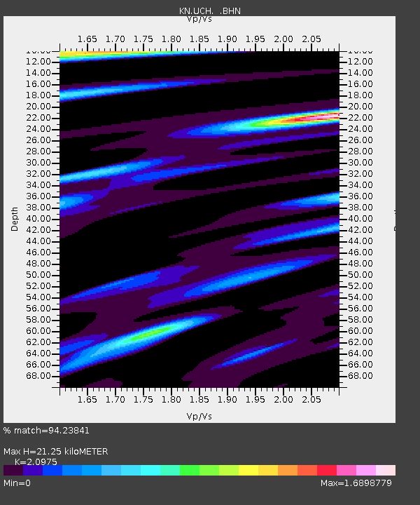
| Estimated Moho Depth: |
21.25 km |
| Estimated Crust Vp/Vs: |
2.10 |
| Assumed Crust Vp: |
6.306 km/s |
| Estimated Crust Vs: |
3.006 km/s |
| Estimated Crust Poisson's Ratio: |
0.35 |
|
| Radial Match: |
94.23841 % |
| Radial Bump: |
347 |
| Transverse Match: |
85.81676 % |
| Transverse Bump: |
400 |
| SOD ConfigId: |
5233 |
| Insert Time: |
2010-03-08 21:30:14.072 +0000 |
| GWidth: |
2.5 |
| Max Bumps: |
400 |
| Tol: |
0.001 |
|
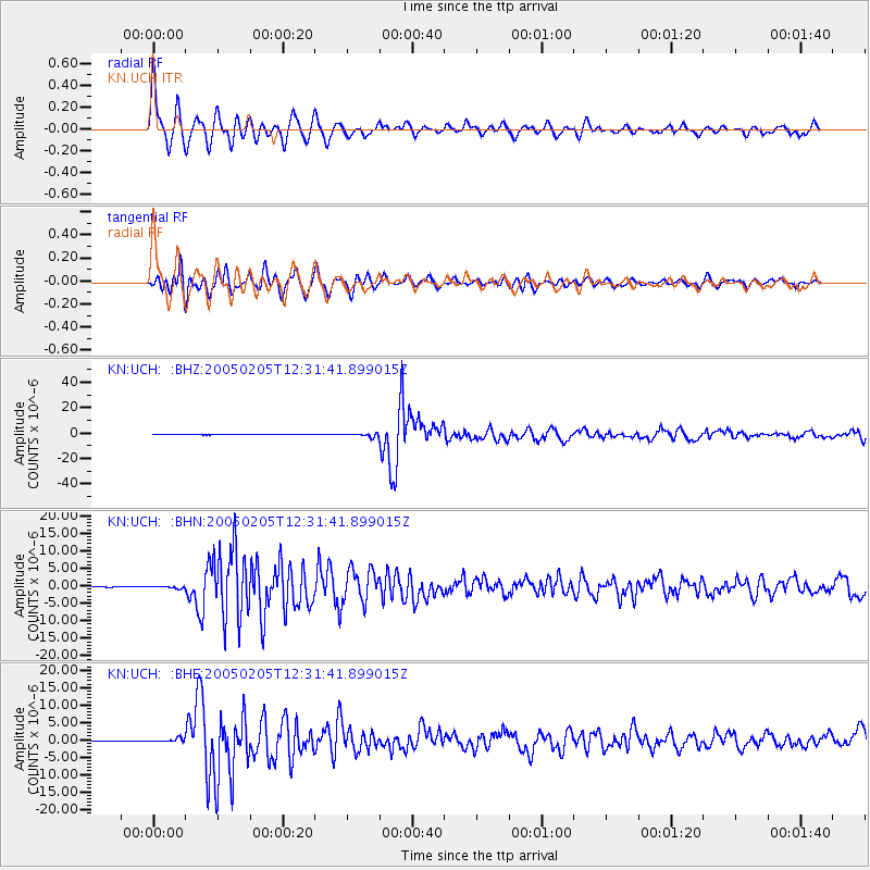
Signal To Noise
| Channel | StoN | STA | LTA |
| KN:UCH: :BHN:20050205T12:31:41.899015Z | 3.4446354 | 2.915526E-7 | 8.463961E-8 |
| KN:UCH: :BHE:20050205T12:31:41.899015Z | 6.654262 | 4.8901956E-7 | 7.348967E-8 |
| KN:UCH: :BHZ:20050205T12:31:41.899015Z | 13.981091 | 1.3488934E-6 | 9.647984E-8 |
| Arrivals |
| Ps | 3.8 SECOND |
| PpPs | 10 SECOND |
| PsPs/PpSs | 14 SECOND |


