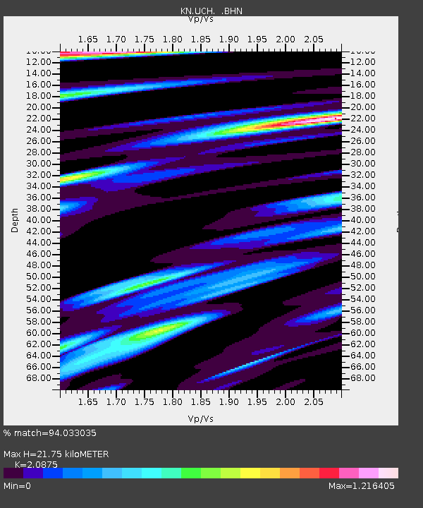
UCH KN.UCH - Earthquake Result Viewer
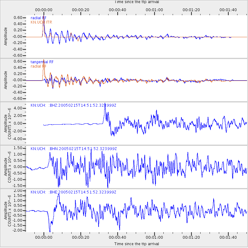
Earthquake location: Talaud Islands, Indonesia
Earthquake latitude/longitude: 4.8/126.4
Earthquake time(UTC): 2005/02/15 (046) 14:42:25 GMT
Earthquake Depth: 40 km
Earthquake Magnitude: 6.1 MB, 6.0 MS, 6.6 MW, 6.4 MW
Earthquake Catalog/Contributor: WHDF/NEIC
Network: KN Kyrgyz Seismic Telemetry Network
Station: UCH KN.UCH
Lat/Lon: 42.23 N/74.51 E
Elevation: 3850 m
Distance: 59.2 deg
Az: 317.125 deg
Baz: 114.08 deg
Ray Param: 0.062255852
Estimated Moho Depth: 21.75 km
Estimated Crust Vp/Vs: 2.09
Assumed Crust Vp: 6.306 km/s
Estimated Crust Vs: 3.021 km/s
Estimated Crust Poisson's Ratio: 0.35
Radial Match: 94.033035 %
Radial Bump: 400
Transverse Match: 66.47505 %
Transverse Bump: 400
SOD ConfigId: 2455
Insert Time: 2010-03-08 21:30:18.202 +0000
GWidth: 2.5
Max Bumps: 400
Tol: 0.001

Signal To Noise

ChannelStoNSTALTA
KN:UCH: :BHN:20050215T14:51:52.323999Z2.75510434.284915E-71.5552641E-7
KN:UCH: :BHE:20050215T14:51:52.323999Z5.99655771.0384155E-61.731686E-7
KN:UCH: :BHZ:20050215T14:51:52.323999Z19.4736841.9500453E-61.0013747E-7
Arrivals
Ps3.9 SECOND
PpPs10 SECOND
PsPs/PpSs14 SECOND