You are here: Home > Network List > IW - Intermountain West Stations List
> Station DLMT Dillon, Montana, USA > Earthquake Result Viewer
DLMT Dillon, Montana, USA - Earthquake Result Viewer
| Earthquake location: |
Near Coast Of Chiapas, Mexico |
| Earthquake latitude/longitude: |
14.9/-92.0 |
| Earthquake time(UTC): |
2017/06/14 (165) 07:29:03 GMT |
| Earthquake Depth: |
98 km |
| Earthquake Magnitude: |
7.0 Mi |
| Earthquake Catalog/Contributor: |
NEIC PDE/at |
|
| Network: |
IW Intermountain West |
| Station: |
DLMT Dillon, Montana, USA |
| Lat/Lon: |
45.36 N/112.60 W |
| Elevation: |
1569 m |
|
| Distance: |
35.0 deg |
| Az: |
334.374 deg |
| Baz: |
143.623 deg |
| Ray Param: |
0.077149555 |
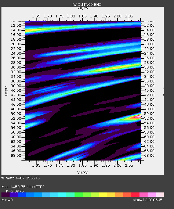
| Estimated Moho Depth: |
50.75 km |
| Estimated Crust Vp/Vs: |
2.10 |
| Assumed Crust Vp: |
6.577 km/s |
| Estimated Crust Vs: |
3.136 km/s |
| Estimated Crust Poisson's Ratio: |
0.35 |
|
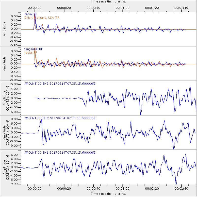
| Radial Match: |
87.855675 % |
| Radial Bump: |
400 |
| Transverse Match: |
69.71569 % |
| Transverse Bump: |
400 |
| SOD ConfigId: |
2140511 |
| Insert Time: |
2017-06-27 23:23:03.387 +0000 |
| GWidth: |
2.5 |
| Max Bumps: |
400 |
| Tol: |
0.001 |
|
Signal To Noise
| Channel | StoN | STA | LTA |
| IW:DLMT:00:BHZ:20170614T07:35:15.600006Z | 29.787474 | 4.0675E-6 | 1.365507E-7 |
| IW:DLMT:00:BH1:20170614T07:35:15.600006Z | 10.328937 | 1.7098557E-6 | 1.6554036E-7 |
| IW:DLMT:00:BH2:20170614T07:35:15.600006Z | 9.177643 | 1.3750517E-6 | 1.4982623E-7 |
| Arrivals |
| Ps | 9.1 SECOND |
| PpPs | 22 SECOND |
| PsPs/PpSs | 31 SECOND |


