You are here: Home > Network List > KN - Kyrgyz Seismic Telemetry Network Stations List
> Station UCH KN.UCH > Earthquake Result Viewer
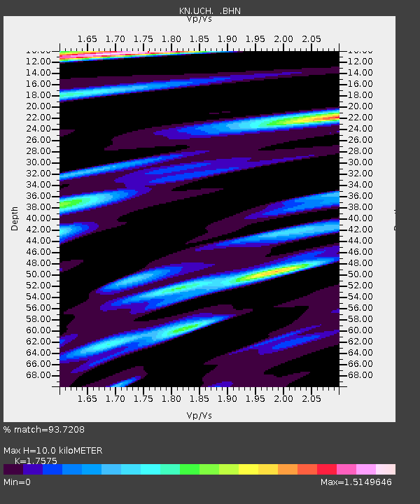
UCH KN.UCH - Earthquake Result Viewer
| Earthquake location: |
Banda Sea |
| Earthquake latitude/longitude: |
-6.5/129.9 |
| Earthquake time(UTC): |
2005/03/02 (061) 10:42:12 GMT |
| Earthquake Depth: |
202 km |
| Earthquake Magnitude: |
7.0 MB, 7.1 MW, 7.1 MW |
| Earthquake Catalog/Contributor: |
WHDF/NEIC |
|
| Network: |
KN Kyrgyz Seismic Telemetry Network |
| Station: |
UCH KN.UCH |
| Lat/Lon: |
42.23 N/74.51 E |
| Elevation: |
3850 m |
|
| Distance: |
69.9 deg |
| Az: |
319.378 deg |
| Baz: |
119.428 deg |
| Ray Param: |
0.05475445 |
| Estimated Moho Depth: |
10.0 km |
| Estimated Crust Vp/Vs: |
1.76 |
| Assumed Crust Vp: |
6.306 km/s |
| Estimated Crust Vs: |
3.588 km/s |
| Estimated Crust Poisson's Ratio: |
0.26 |
|
| Radial Match: |
93.7208 % |
| Radial Bump: |
400 |
| Transverse Match: |
92.657486 % |
| Transverse Bump: |
400 |
| SOD ConfigId: |
2455 |
| Insert Time: |
2010-03-08 21:30:21.489 +0000 |
| GWidth: |
2.5 |
| Max Bumps: |
400 |
| Tol: |
0.001 |
|

Signal To Noise
| Channel | StoN | STA | LTA |
| KN:UCH: :BHN:20050302T10:52:30.448994Z | 40.776695 | 3.978631E-6 | 9.7571196E-8 |
| KN:UCH: :BHE:20050302T10:52:30.448994Z | 49.59325 | 6.2176446E-6 | 1.253728E-7 |
| KN:UCH: :BHZ:20050302T10:52:30.448994Z | 149.38196 | 2.2598593E-5 | 1.5128062E-7 |
| Arrivals |
| Ps | 1.2 SECOND |
| PpPs | 4.2 SECOND |
| PsPs/PpSs | 5.5 SECOND |


