You are here: Home > Network List > NE - New England Seismic Network Stations List
> Station HNH Hanover, NH, USA > Earthquake Result Viewer
HNH Hanover, NH, USA - Earthquake Result Viewer
| Earthquake location: |
Near Coast Of Chiapas, Mexico |
| Earthquake latitude/longitude: |
14.9/-92.0 |
| Earthquake time(UTC): |
2017/06/14 (165) 07:29:03 GMT |
| Earthquake Depth: |
98 km |
| Earthquake Magnitude: |
7.0 Mi |
| Earthquake Catalog/Contributor: |
NEIC PDE/at |
|
| Network: |
NE New England Seismic Network |
| Station: |
HNH Hanover, NH, USA |
| Lat/Lon: |
43.71 N/72.29 W |
| Elevation: |
180 m |
|
| Distance: |
33.3 deg |
| Az: |
26.474 deg |
| Baz: |
216.462 deg |
| Ray Param: |
0.07800534 |
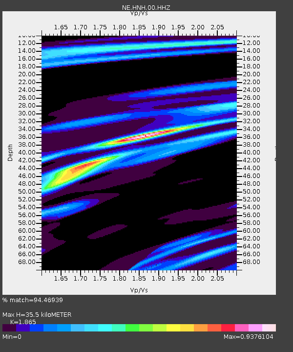
| Estimated Moho Depth: |
35.5 km |
| Estimated Crust Vp/Vs: |
1.87 |
| Assumed Crust Vp: |
6.419 km/s |
| Estimated Crust Vs: |
3.442 km/s |
| Estimated Crust Poisson's Ratio: |
0.30 |
|
| Radial Match: |
94.46939 % |
| Radial Bump: |
222 |
| Transverse Match: |
84.56415 % |
| Transverse Bump: |
376 |
| SOD ConfigId: |
2140511 |
| Insert Time: |
2017-06-27 23:23:29.672 +0000 |
| GWidth: |
2.5 |
| Max Bumps: |
400 |
| Tol: |
0.001 |
|

Signal To Noise
| Channel | StoN | STA | LTA |
| NE:HNH:00:HHZ:20170614T07:35:00.873993Z | 43.22551 | 7.870756E-6 | 1.8208591E-7 |
| NE:HNH:00:HH1:20170614T07:35:00.873993Z | 33.127758 | 4.8353454E-6 | 1.4596053E-7 |
| NE:HNH:00:HH2:20170614T07:35:00.873993Z | 12.261055 | 1.3777167E-6 | 1.1236526E-7 |
| Arrivals |
| Ps | 5.1 SECOND |
| PpPs | 15 SECOND |
| PsPs/PpSs | 20 SECOND |


