You are here: Home > Network List > KN - Kyrgyz Seismic Telemetry Network Stations List
> Station UCH KN.UCH > Earthquake Result Viewer
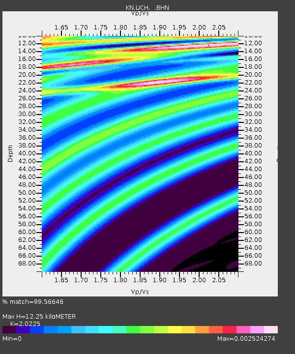
UCH KN.UCH - Earthquake Result Viewer
| Earthquake location: |
Off W Coast Of Northern Sumatra |
| Earthquake latitude/longitude: |
2.9/95.5 |
| Earthquake time(UTC): |
2007/09/29 (272) 05:32:44 GMT |
| Earthquake Depth: |
35 km |
| Earthquake Magnitude: |
5.5 MB, 5.7 MW, 5.6 MW |
| Earthquake Catalog/Contributor: |
WHDF/NEIC |
|
| Network: |
KN Kyrgyz Seismic Telemetry Network |
| Station: |
UCH KN.UCH |
| Lat/Lon: |
42.23 N/74.51 E |
| Elevation: |
3850 m |
|
| Distance: |
43.4 deg |
| Az: |
337.186 deg |
| Baz: |
148.575 deg |
| Ray Param: |
0.07248676 |
| Estimated Moho Depth: |
12.25 km |
| Estimated Crust Vp/Vs: |
2.02 |
| Assumed Crust Vp: |
6.306 km/s |
| Estimated Crust Vs: |
3.118 km/s |
| Estimated Crust Poisson's Ratio: |
0.34 |
|
| Radial Match: |
99.56646 % |
| Radial Bump: |
27 |
| Transverse Match: |
99.79218 % |
| Transverse Bump: |
15 |
| SOD ConfigId: |
2564 |
| Insert Time: |
2010-03-08 21:31:08.182 +0000 |
| GWidth: |
2.5 |
| Max Bumps: |
400 |
| Tol: |
0.001 |
|

Signal To Noise
| Channel | StoN | STA | LTA |
| KN:UCH: :BHN:20070929T05:40:13.123014Z | 0.88572395 | 2.5045316E-7 | 2.827666E-7 |
| KN:UCH: :BHE:20070929T05:40:13.123014Z | 1.0009093 | 4.937422E-7 | 4.932936E-7 |
| KN:UCH: :BHZ:20070929T05:40:13.123014Z | 1.8873572 | 6.3957026E-7 | 3.3887082E-7 |
| Arrivals |
| Ps | 2.1 SECOND |
| PpPs | 5.6 SECOND |
| PsPs/PpSs | 7.7 SECOND |


