You are here: Home > Network List > US - United States National Seismic Network Stations List
> Station AHID Auburn Hatchery, Idaho, USA > Earthquake Result Viewer
AHID Auburn Hatchery, Idaho, USA - Earthquake Result Viewer

| Earthquake location: |
Near Coast Of Chiapas, Mexico |
| Earthquake latitude/longitude: |
14.9/-92.0 |
| Earthquake time(UTC): |
2017/06/14 (165) 07:29:03 GMT |
| Earthquake Depth: |
98 km |
| Earthquake Magnitude: |
7.0 Mi |
| Earthquake Catalog/Contributor: |
NEIC PDE/at |
|
| Network: |
US United States National Seismic Network |
| Station: |
AHID Auburn Hatchery, Idaho, USA |
| Lat/Lon: |
42.77 N/111.10 W |
| Elevation: |
1960 m |
|
| Distance: |
32.3 deg |
| Az: |
333.163 deg |
| Baz: |
143.651 deg |
| Ray Param: |
0.07847188 |
| Estimated Moho Depth: |
11.5 km |
| Estimated Crust Vp/Vs: |
2.07 |
| Assumed Crust Vp: |
6.207 km/s |
| Estimated Crust Vs: |
2.998 km/s |
| Estimated Crust Poisson's Ratio: |
0.35 |
|
| Radial Match: |
93.1878 % |
| Radial Bump: |
400 |
| Transverse Match: |
78.946304 % |
| Transverse Bump: |
400 |
| SOD ConfigId: |
2140511 |
| Insert Time: |
2017-06-27 23:24:09.123 +0000 |
| GWidth: |
2.5 |
| Max Bumps: |
400 |
| Tol: |
0.001 |
|
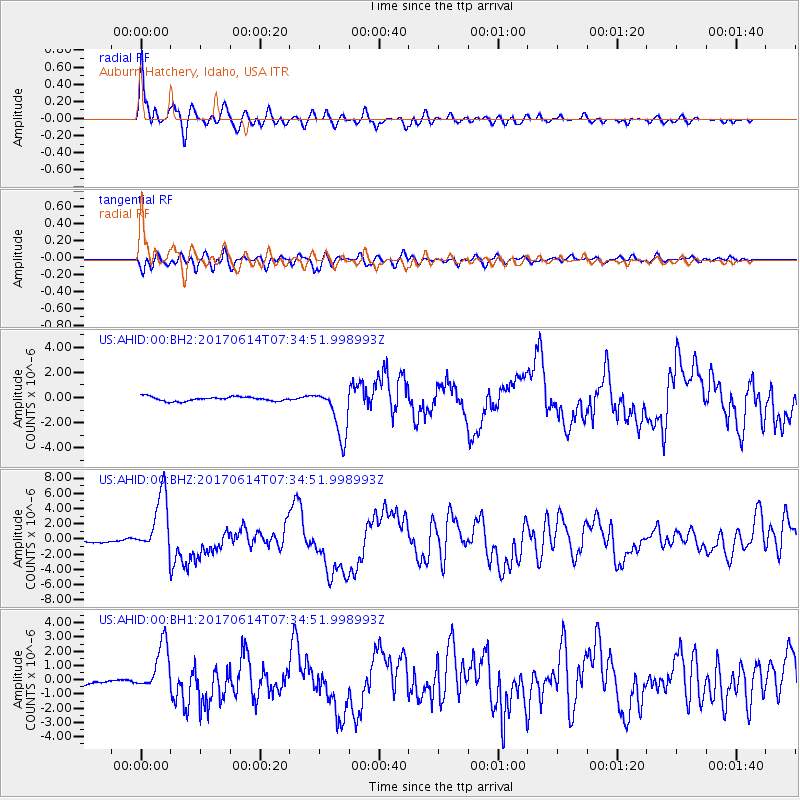
Signal To Noise
| Channel | StoN | STA | LTA |
| US:AHID:00:BHZ:20170614T07:34:51.998993Z | 26.236792 | 3.9736733E-6 | 1.5145424E-7 |
| US:AHID:00:BH1:20170614T07:34:51.998993Z | 14.919415 | 1.6990753E-6 | 1.138835E-7 |
| US:AHID:00:BH2:20170614T07:34:51.998993Z | 11.767604 | 1.9749211E-6 | 1.6782695E-7 |
| Arrivals |
| Ps | 2.1 SECOND |
| PpPs | 5.3 SECOND |
| PsPs/PpSs | 7.5 SECOND |


