You are here: Home > Network List > TA - USArray Transportable Network (new EarthScope stations) Stations List
> Station E20K Nigu River, AK, USA > Earthquake Result Viewer
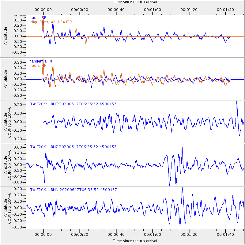
E20K Nigu River, AK, USA - Earthquake Result Viewer
*The percent match for this event was below the threshold and hence no stack was calculated.
| Earthquake location: |
Tonga Islands |
| Earthquake latitude/longitude: |
-16.1/-175.0 |
| Earthquake time(UTC): |
2020/06/17 (169) 06:24:18 GMT |
| Earthquake Depth: |
280 km |
| Earthquake Magnitude: |
5.6 Mww |
| Earthquake Catalog/Contributor: |
NEIC PDE/us |
|
| Network: |
TA USArray Transportable Network (new EarthScope stations) |
| Station: |
E20K Nigu River, AK, USA |
| Lat/Lon: |
68.26 N/156.19 W |
| Elevation: |
866 m |
|
| Distance: |
85.3 deg |
| Az: |
6.918 deg |
| Baz: |
198.102 deg |
| Ray Param: |
$rayparam |
*The percent match for this event was below the threshold and hence was not used in the summary stack. |
|
| Radial Match: |
72.36077 % |
| Radial Bump: |
400 |
| Transverse Match: |
56.49395 % |
| Transverse Bump: |
400 |
| SOD ConfigId: |
21709731 |
| Insert Time: |
2020-07-01 06:40:30.026 +0000 |
| GWidth: |
2.5 |
| Max Bumps: |
400 |
| Tol: |
0.001 |
|
Signal To Noise
| Channel | StoN | STA | LTA |
| TA:E20K: :BHZ:20200617T06:35:52.450015Z | 4.3118706 | 2.3374909E-7 | 5.42106E-8 |
| TA:E20K: :BHN:20200617T06:35:52.450015Z | 0.9515704 | 6.367941E-8 | 6.6920336E-8 |
| TA:E20K: :BHE:20200617T06:35:52.450015Z | 1.3105637 | 4.2593868E-8 | 3.2500417E-8 |
| Arrivals |
| Ps | |
| PpPs | |
| PsPs/PpSs | |


